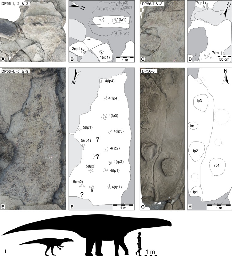
Figure 3. Dinosaurian track-bearing platforms in the Lower Cretaceous Broome Sandstone at Minyirr (UQL-DP56).
Orthophotographic mosaics derived from ground-based photogrammetry with accompanying schematic interpretations. (A, B) in situ and ex situ theropod tracks (UQL-DP56-1, -2 and -3), orthophotographic mosaic and schematic, respectively (asterisk indicates ex situ track; double asterisk indicates underside of ex situ track surface). (C, D) in situ theropod tracks (UQL-DP56-7) and position of eroded track (UQL-DP56-8), orthophotographic mosaic and schematic, respectively. (E, F) in situ theropod trackways (UQL-DP56-4, -5 and -9), orthophotographic mosaic and schematic, respectively. (G, H) in situ sauropod trackway (UQL-DP56-6, orthophotographic mosaic and schematic, respectively, showing expected track positions for lost tracks (i.e., dotted circles). (I) silhouettes of hypothetical theropod and sauropod to indicate the relative trackmaker size compared with that of 1.8 m human. Grey arrow within dash-stroked circle indicates orientation and relative in situ track position prior to 2015. Within trackway numbering ‘l’ and ‘r’ refer to left and right impressions, respectively. Arrow indicates magnetic north (true north is approximately 2°E).

