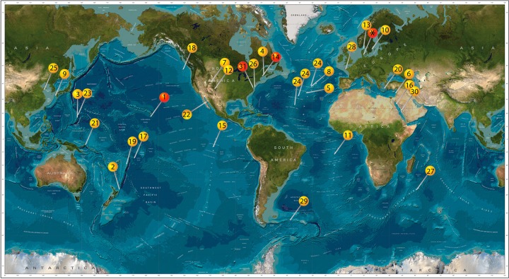
FIG 1.
World map showing locations where evidence for the presence of Zetaproteobacteria is present based on molecular data (yellow pins) and where in addition to molecular data isolates are also present (red pins). 1, Lō'ihi Seamount (14, 20, 22, 24, 30, 58, 74, 75); 2, Kermandec Arc (76); 3, Southern Mariana Trough (16, 77, 78); 4, Sheepscot River, Maine, USA (50); 5 and 8, Mid-Atlantic Ridge (79, 80); 6, Levantine basin, (12); 7, Crystal Geyser, Utah, USA (81); 9, Nagahama Bay (57); 10, Äspö Hard Rock Laboratory (82); 11, South Mid-Atlantic Ridge (83); 12, springs in New Mexico, USA (84); 13, Skagerrak (49); 14, Boothbay Harbor, Maine, USA (17); 15, East Pacific Rise (85); 16, Kebrit Deep, Red Sea (86); 17, Vailulu'u Seamount (87); 18, Juan de Fuca Ridge (88, 89); 19, Tonga Arc (15); 20, Nea Kameni Island, Greece (90); 21, Tutum Bay, Ambitle Island (91); 22, Southern Guyamas vent field (92); 23, Southern Mariana Trench (93); 24, Mid-Atlantic Ridge (various sites) (21); 25, Quingdao coastal waters (18); 26, beach aquifer, Cape Shores, Lewes, Delaware, USA (94); 27, Indian Ridge (95); 28, tidal basin Aber-Benoıt, Treglonou, France (96); 29, surface water between the Polar Front and the Southern Antarctic Circumpolar Current in the Southern Ocean (97); 30, water desalination plant in Saudi Arabia (98); 31 Chesapeake Bay, USA (19); *, Aarhus Bay (this study). This image builds upon previous work by McAllister et al. (20). (Image reproduced from the GEBCO world map, 2014 [www.gebco.net].)

