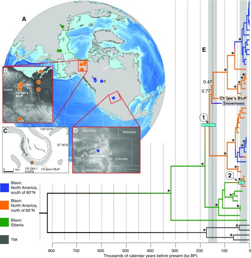
Fig. 1.
(A) Localities of the 36 fossil bison. Siberia: green; North America north of 60° N: orange; North America south of 60° N: blue. The number of samples is given in italics if >one sample was recovered. The green dashed lines outline the last glacial maximum Bering Land Bridge extent. Insets showing locations of (B) CRH 11 (labeled orange circle) and Ch’ijee’s Bluff (orange star) in northern Yukon, with (C) a zoom-in on Ch’ijee’s Bluff, and (D) Snowmass, Colorado (blue star). (E) Bayesian phylogeny resulting from analysis of the reduced mitochondrial alignment, calibrated using the ages of the bison fossils from which data were generated. Nodes with posterior support of >0.99 are indicated with a black asterisk and other values are provided for deep nodes. The positions of the Ch’ijee’s Bluff and Snowmass bison are highlighted. We identify two waves of dispersal from Asia into North America via the Bering Land Bridge (nodes 1 and 2), with date ranges indicated as light blue bars. Areas of gray shading indicate intervals of lowered sea level sufficient to expose the Bering Land Bridge (36).

