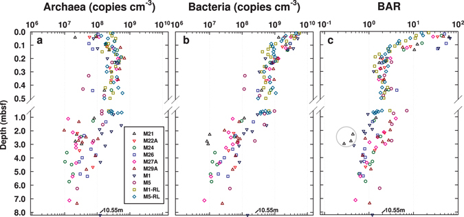
Figure 1.

(a) Archaeal and (b) bacterial 16S rRNA gene copy numbers (copies cm−3 wet sediment) and (c) BARs across a transect of eight stations in Aarhus Bay. The gray circle in (c) marks sediment samples from an organic-poor glacial sand layer at the bottom of M21. The SMTZ was reached at all stations except M21 and M22A, and varied greatly in depth and width (M24: 3.36–4.31 mbsf; M26: 2.04–3.78 mbsf; M27A: 2.62–2.90 mbsf; M29A: 2.20–2.75 mbsf; M1: 1.40–1.60 mbsf; M5: 0.47–0.58 mbsf). Free methane gas was detected at five stations (M26: ≥7.04 mbsf, M27A: ≥4.70 mbsf; M29A: ≥4.45 mbsf; M1: ≥4.00 mbsf; M5: ≥1.00 mbsf). Gravity and Rumohr cores were taken from M21, M22A, M24, M26, M27A, M29A, and M5 in May 2010, and from M1 in October 2009. Additional, increased sample-resolution Rumohr cores from M1 (M1-RL) and M5 (M5-RL) were obtained in March 2012.
