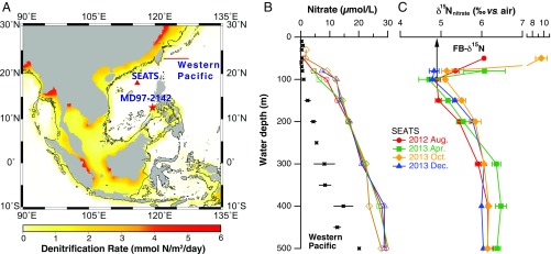
Fig. 1.
Core location and modern context for this study. (A) Topographic map showing the change in basin configuration around the SCS between interglacial sea level high stand and full glacial sea level low stand, assuming a 120-m lowering of the shore line on modern topography (63) (black contour; modern land area shown in gray). The locations of the coring site for core MD97-2142, the SEATS, and the hydrographic transect in the open western Pacific are shown with a star, triangle, and line, respectively. Colors depict model-simulated benthic denitrification rate (millimoles of N per square meter per day) (8). The 120-m ice age sea level lowering exposes almost all of the shallow shelf where benthic denitrification is rapid in the present day. (B and C) The depth profiles of the concentration and δ15N of nitrate plus nitrite in the upper 500 m at SEATS. The samples are collected from four cruises from 2012 summer to 2013 winter (indicated with different colors and symbols). The error bar at each depth indicates 1 SD associated with water collections from multiple casts during each cruise. The depth profile of the nitrate plus nitrite concentration in the open western Pacific is also shown for comparison (black squares). The remineralization of newly fixed N is taken as the dominant contributor to the subsurface nitrate δ15N minimum and also lowers the nitrate δ15N throughout the water column (22). The FB-δ15N of both G. ruber and O. universa measured at the surface sediment are 4.9‰ (black arrow), similar to the δ15N of the shallow thermocline nitrate being supplied to the photic zone.

