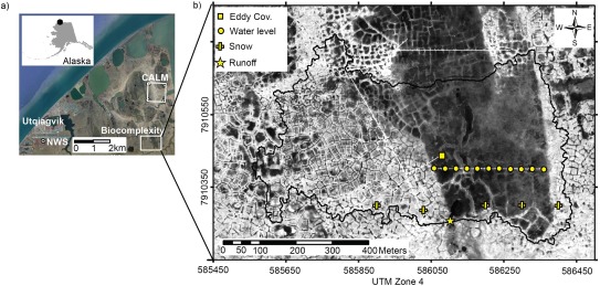
Figure 1.

Locations of the long‐term meteorological data from the National Weather Service station at Utgiagvik Airport (NWS), the end‐of‐winter snow survey location (1999–2014) for (a) the Circumpolar Active Layer Monitoring Grid (CALM), and (b) the Biocomplexity watershed (0.3 km2) near Utgiagvik (formerly Barrow), Northern Alaska. Within the watershed are the west‐east transect of water table observations (Water level), 2008 and 2009 snow ablation monitoring sites (Snow), and runoff monitoring point (Runoff), eddy covariance tower and soil moisture measurements (Eddy Cov.). The dominating patterned ground features are low‐centered polygons, both without (mainly in the drained thaw lake basin) and with troughs, while high‐centered polygons are found in the upland area of the southcentral and easternmost portions. In general, the darker the shade the more surface moisture in the QuickBird panchromatic satellite image from 1 to 2 August 2002 [Manley et al., 2006]. The larger image of Utgiagvik area is from GoogleEarth.
