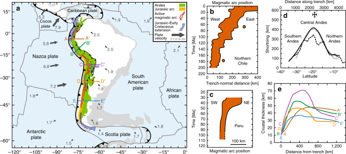
Fig. 1.
Tectonics and geology of the Andes region. a Tectonic map showing the current plate velocities, the Andes mountain belt, Jurassic-Early Cretaceous extension in the Andean region9, the Jurassic magmatic arc (Methods section) and the present magmatic arc. Note that the five transects (A-A’, B-B’, C-C’, D-D’, E-E’) are shown in e. b, c Evolution of the magmatic arc position in Northern Chile (21°–26°S, based on Scheuber et al.8) and Peru (simplified from Jaillard and Soler11). d Trench-parallel variation in Andean shortening. Continuous black line is based on balanced cross-sections and Eocene-present tectonic reconstruction19, dotted grey line is based on Eocene-present tectonic reconstruction18, dashed black line is based on crustal thickness (assuming an original thickness of 40 km)17, and Central Andes data point is based on structural mapping of Late Cretaceous-present deformation12. e Profiles showing the crustal thickness in five locations (see a) along the Andes (derived from the crustal thickness map of Chulick et al.20)

