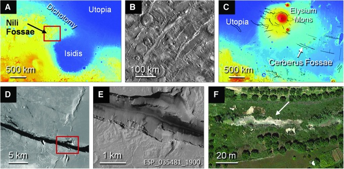
FIG. 11.
Faults and fractures at Nili Fossae and Cerberus Fossae with comparison to a terrestrial gas-releasing fissure. (A–B) Nili Fossae. (A) Regional image on basemap of MOLA topography. Elevation as in Fig. 2A. Red rectangle is the area of (B). (B) Daytime IR image mosaic from the THEMIS spectrometer on the Mars Odyssey orbiter. (C–E) Cerberus Fossae. (C) Regional image on basemap of MOLA topography, showing location of Cerberus Fossae. Elevation as in Fig. 2A. Scarps and faults are shown in black, using data from the US Geological Survey Global Map SIM3292(2014) and extensional faults provided in the USGS Mars Global GIS DVD version 2.1. Arrow points to approximate location of (D). (D) Closer view of one of the fractures of the Cerberus Fossae, on CTX mosaic. (E) HiRISE image showing sharp, unweathered edges of one of the Cerberus Fossae fractures and potential flow structures emanating from the southern edge. (F) Faros gas seep fissure, Greece. Arrow points to disturbed vegetation along fissure from which gas emanates. Centerpoints: (D) 10.04°N, 157.85°E; (E) 9.96°N, 157.94°E; (F) 37.64°N, 21.31°E. Image credits: (A, C) MOLA basemap: NASA/JPL-Caltech/GSFC; (B) Google, NASA and NASA/JPL-Caltech/Arizona State University; (D) Google, NASA and NASA/JPL/MSSS; (E) NASA/JPL/University of Arizona; (F) Google, 2016 TerraMetrics.

