
Fig. 1. Site locations and the spatial pattern of modern ISM precipitation.
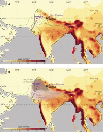
(A) The spatial extent of the Indus Valley Civilization [IVC; ~5300–3300 years before present (yr BP)] is marked by dotted green lines along with the Indus River (brown line). Shading indicates the spatial pattern of JJAS (June to September) rainfall rate (mm/day) from the gridded precipitation data set from the Global Precipitation Climatology Centre Monitoring Product v5 (56). The Sahiya Cave is shown by a black star. (B) Same as (A), except spatial extent of the Early (~3400–3050 yr BP) and Later (~3050–2450 yr BP) Vedic periods are shown. Hexagons depict other cave sites mentioned in the text.