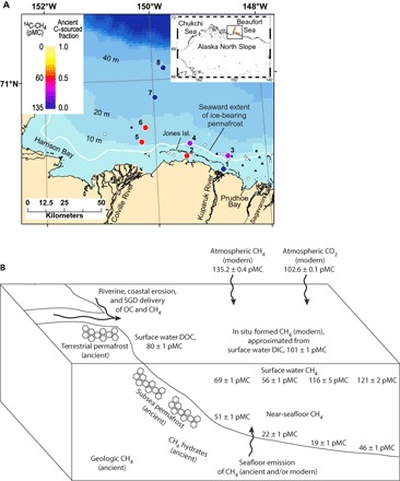
Fig. 1. Surface water 14C-CH4 data and potential CH4 endmembers in the U.S. Beaufort Sea shelf study area.

(A) Station map showing both the 14C-CH4 data in units of percent Modern Carbon (pMC), with the atmosphere in 1950 defined as 100 pMC (33, 34), as well as the calculated fraction of ancient C–sourced CH4 (fs) (Eqs. 1 to 5) in surface waters at each station. The white curve is the bulk sediment velocity contour (2000 m/s) used to delineate the seaward boundary of the sedimentary section that contains substantial (up to 29%) ice-bearing permafrost in the upper ~600 m (21). White circles and triangles respectively show boreholes (hundreds of meters deep) and geotechnical borings (<100 m) that contain permafrost based on an analysis of well logs and recovery of permafrost samples, respectively (22). Black circles and triangles respectively indicate no permafrost inferred or found in deep boreholes and geotechnical borings (22). (B) System schematic showing 14C values of dissolved CH4 (stations 5 to 8) and possible ancient and modern endmembers that were also measured here. SGD, submarine groundwater discharge; OC, organic carbon; DOC, dissolved organic carbon.
