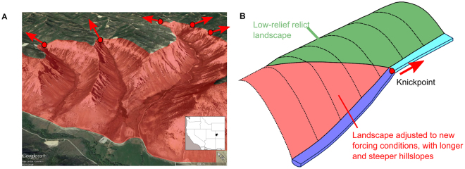
Figure 1.
(A) Oblique aerial view of the Roan Plateau, Colorado, USA (image from Landsat/Copernicus in Google Earth, © Google.), with the location of knickpoints identified with the red dots. The red shaded area highlights the area of the landscape that has adjusted to the new base level conditions while the relict low relief landscape can be seen upstream of the knickpoints (Inset made with Natural Earth, Free vector and raster map data @ naturalearthdata.com). (B) Conceptual diagram illustrating how waterfalls or reaches of steepened channel slope, collectively termed ‘knickpoints’, represent dynamic locations within the river network, separating the part of the landscape adjusted to the new conditions (downstream – red) and those that are yet to adjust (green) (adapted from Hurst et al.7).

