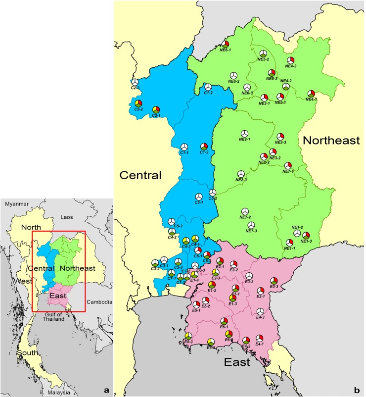
Fig 1. Map of the presence of B. pseudomallei, B. thailandensis and B. thailandensis expressing B. pseudomallei-like capsular polysaccharide (BTCV) in 61 rice fields in Northeast (n = 21), East (n = 19) and Central (n = 21) Thailand.
(a) Map of Thailand. (b) Location of the 61 rice fields evaluated. Red, green and yellow pies represent rice fields that were culture positive and negative for B. pseudomallei, B. thailandensis, and BTCV, respectively. Province codes represent Burirum (NE1), Chaiyaphum (NE2), Khon Kaen (NE3), Udon Thani (NE4), Nong Bua Lam Phu (NE5), Loei (NE6) and Nakhon Ratchasima (NE7) in the Northeast, Chachoengsao (E1), Prachinburi (E2), Sa Kaeo (E3), Chanthaburi (E4), Chonburi (E5) and Rayong (E6) in the East, Phetchabun (C1), Phitsanulok (C2), Pathum Thani (C3), Saraburi (C4), Lopburi (C5), Nakhon Nayok (C6) and Bangkok (C7) in Central Thailand. ArcGis Version 10.2 (ESRI, Redlands, CA, USA) was used to map the sampled rice fields. The location of sampled rice fields was recorded by using the EpiCollect application (www.epicollect.net, Imperial College, London).

