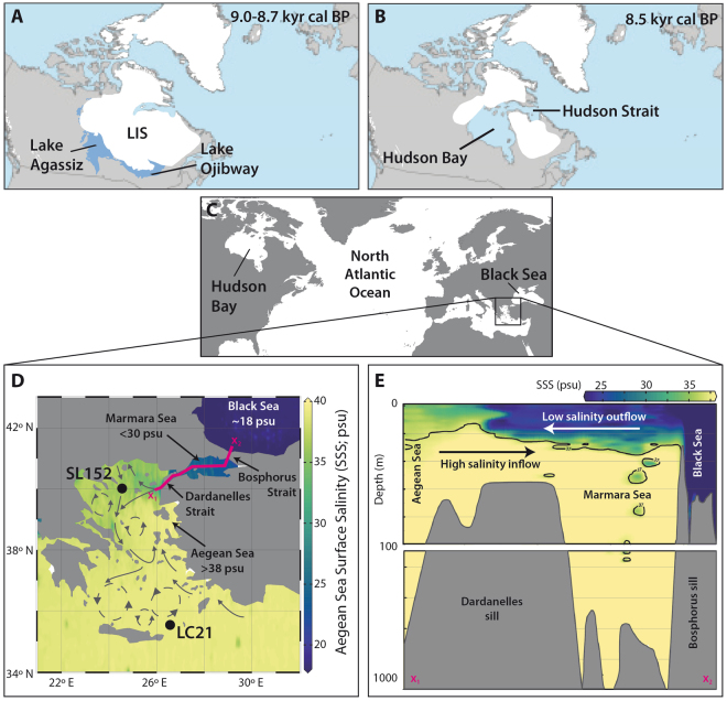
Figure 1.
Extent of North American ice sheets during the early Holocene, location and oceanography of the studied area. (A,B) Final stage of the proglacial Lake Agassiz between about 9.0–8.7 kyrs cal BP and drainage through the Hudson Bay into the North Atlantic at about 8.5 kyrs cal BP2; LIS = Laurentide ice sheet modified after ref.2, reprinted by permission from Macmillan Publishers Ltd: Nature Geoscience (Törnqvist and Hijma, Links between early Holocene icesheet decay, sealevel rise and abrupt climate change), copyright (2012). (C) Northern Hemisphere map showing the studied Aegean Sea and Black Sea areas. (D) Location of the Aegean Sea sediment cores GeoTÜ SL152 (this study) and LC21 in relation to sea-surface salinity35 and the main surface water circulation patterns of the region following ref.14 (reprinted from Quaternary Science Reviews, volume 28, Marino et al., Early and Middle Holocene in the Aegean Sea: interplay between high and low latitude climate variability, p. 3, Copyright (2009), with permission from Elsevier. (E) Illustrative SSS depth profile across transect x1 – x2 (as shown on D) showing the present-day two-layer circulation. The maps C, D, and E are plotted using ocean data view ODV 4.7.10 (Schlitzer, R. Ocean Data View, odv.awi.de, 2017) using the salinity dataset of ref.35 that can be downloaded at https://odv.awi.de/data/ocean/medatlasii/.

