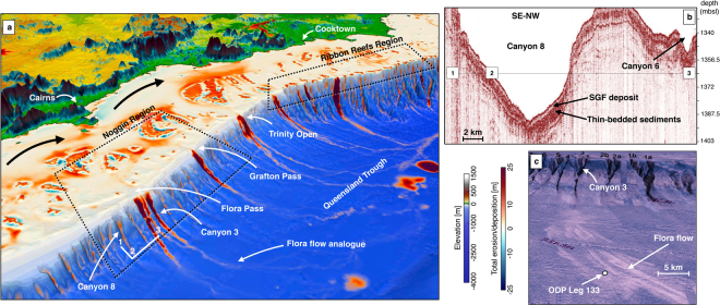
Figure 6.
(a) 3D view of the GBR between Cairns and Cooktown highlighting sediment transport from mountain ranges to the coast, and from the coast to the Queensland Trough (generated using Paraview (V 5.2.0)). On the inner shelf dominant wave direction (SE) rework sediments to the North (black arrows). On the mid shelf, coral reef develops. Sediment transfer across the slope happens through V-shaped canyons. White lines (1–2–3) mark the location of seismic lines in b. (b) Topas seismic section illustrating sediment gravity flow (SGF) and thin-bedded deposits for Canyon 8. (c) 3D view of the Noggin region (canyons and slope) with draped GLORIA side-scan sonar backscatter imagery. High-reflectivity (white toned) areas correspond to SGFs and landslide deposits (b and c are adapted from Puga-Bernabéu et al.58).

