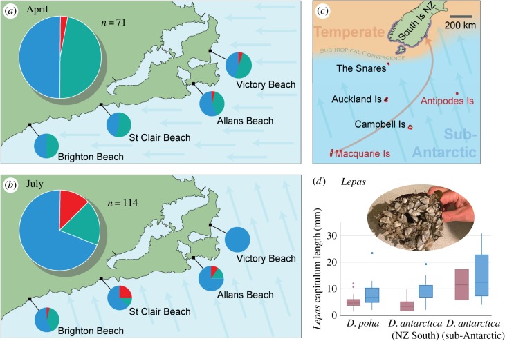
Figure 4.
Provenance of beach-cast kelp samples collected from Otago beaches in (a) April and (b) July 2017 (table 1) based on DNA sequencing. Sampling was restricted to specimens covered in L. australis barnacles, in order to avoid material of local origin. For (a) and (b), proportions of each haplogroup are shown in total in the large pie chart, and for each site in smaller pie charts, with blue representing D. antarctica haplotypes from southern New Zealand, green representing haplotypes of D. poha and red representing D. antarctica haplotypes previously only detected at sub-Antarctic locations. (c) Map showing distributions of D. antarctica haplogroups, with blue outline (South Island NZ and Stewart Island) representing the ‘NZSth’ haplogroup, and red outline representing the ‘Subant’ haplogroup. Sites in this region from which the ‘Subant1’ haplotype has previously been detected in attached populations are labelled in red text. The inferred dispersal from Macquarie Is across the STF barrier to southeastern New Zealand is indicated schematically by an orange arrow, and the prevailing wind direction in July 2017 storm event is shown by blue arrows. (d) Box and whisker plots of Lepas capitulum length on beach-cast kelp rafts in April (purple) and July (blue) for each haplogroup. A photo of large Lepas on one of the kelp holdfasts is shown (inset). (Online version in colour.)

