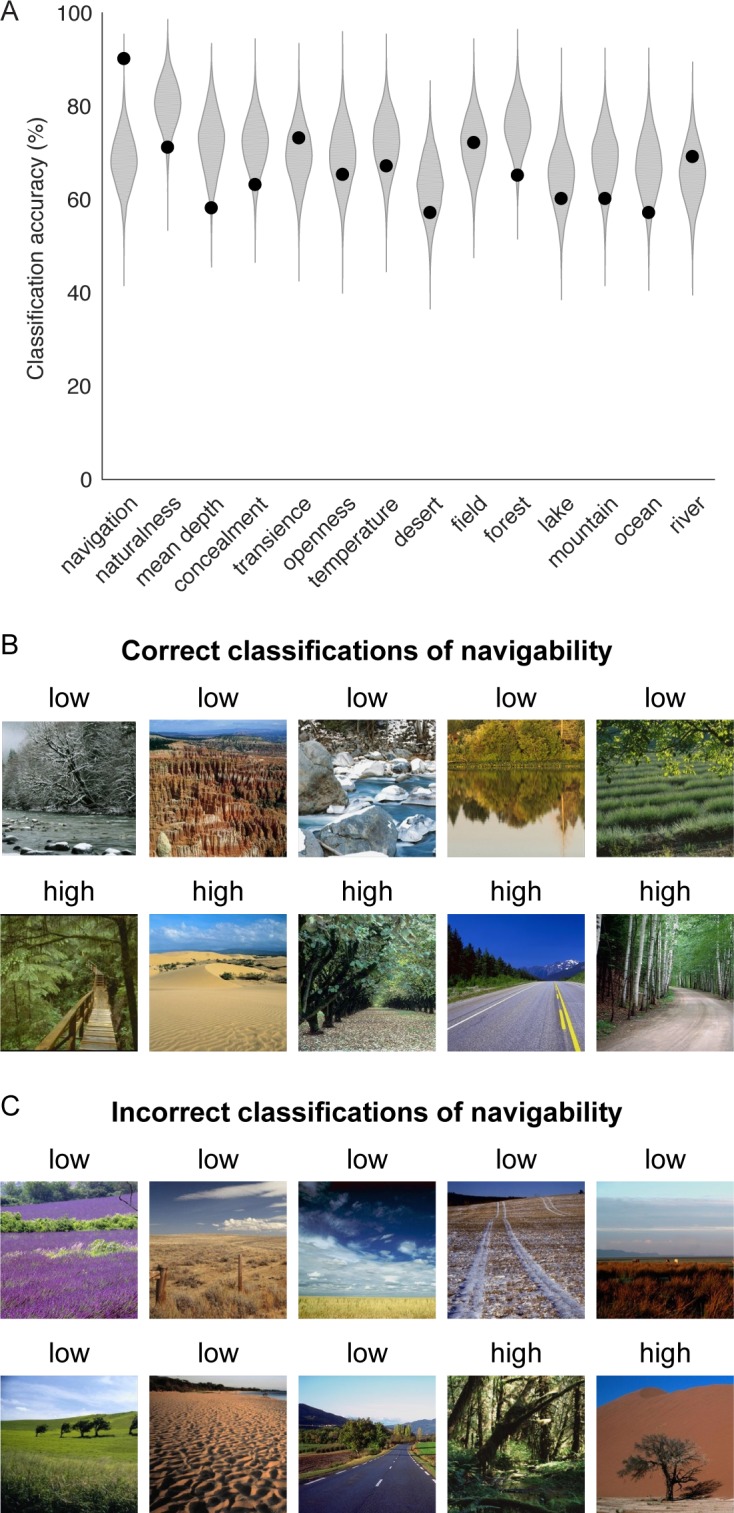
Fig 7. Classification of navigability in natural landscapes.

(A) Units from layer 5 of the CNN were used to classify navigability and other scene properties in a set of natural outdoor scenes. Classifier performance was examined for a subset of units that were strongly associated with navigational-affordance representation in our previous analyses of indoor scenes. Specifically, a classifier was created from the 50 units in layer 5 that were selected for the visualization analyses in Fig 6. For comparison, a resampling distribution was generated by randomly selecting 50 units from layer 5 over 5,000 iterations and submitting these units to the same classification procedures. Classification accuracy was quantified through leave-one-out cross-validation. For each scene property, the label for a given image was predicted from a linear classifier trained on all other images. This procedure was repeated for each image in turn, and accuracy was calculated as the percentage of correct classifications across all images. In this plot, the black dots indicate the classification accuracies obtained from the 50 affordance-related CNN units, and the shaded kernel density plots indicate the accuracy distributions obtained from randomly resampled units. Each kernel density distribution was mirrored across the vertical axis, with the area in between shaded gray. These analyses showed that the strongly affordance-related units performed at 90% accuracy when classifying natural landscapes based on navigation (i.e., overall navigability). This accuracy was in the 99th percentile of the resampling distribution, suggesting that these units were particularly informative for identifying scene navigability. Furthermore, these units were more accurate at classifying navigation than any other scene property. (B) Examples of images that were correctly classified into the categories of low or high navigability based on the responses of the affordance-related units. These images illustrate some of the high-level scene features that influenced overall navigability, including spatial layout, textures, and material properties. (C) All images that were misclassified into categories of low or high navigability based on the responses of the affordance-related units. The label above each image is the incorrect label produced by the classifier. Many of the misclassified images contain materials on the ground plane that were uncommon in this stimulus set.
