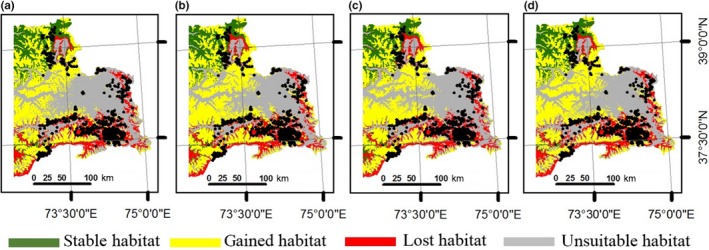
Figure 4.

Comparison of suitable habitat distributions between present and future scenarios for Marco Polo argali in eastern Tajikistan using all environmental variables (climatic and nonclimatic). Future model was based on general circulation models projected according to: (a) RCP 4.5 to the year 2050; (b) RCP 8.5 to the year 2050; (c) RCP 4.5 to the year 2070; (d) RCP 8.5 to the year 2070. Maps show areas where present and future habitats agree (stable in green), future habitat projects new suitable conditions (gained in yellow), present suitable habitat may be converted to unsuitable in the future (lost in red), and areas where conditions are unsuitable now and in the future (unsuitable in gray). Black dots represent argali occurrence in our data sets. The entire map was generated using the tool of ArcGIS 10.2 (ESRI, Redlands, CA, USA, http://www.esri.com/)
