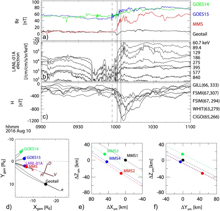
Figure 1.

Overview of the 10 August 2016, 0957 universal time (UT) substorm. (a) Bz component of the magnetic field obtained from Geostationary Operational Environmental Satellite (GOES) 14 (green), GOES 15 (blue), Magnetospheric Multiscale (MMS) (red), and Geotail (black); (b) electron differential flux from LANL‐01A; (c) horizontal component of the geomagnetic field from ground stations; (d) location of the different spacecraft in the equatorial plane. Relative location of MMS spacecraft in (e) x‐z and (f) y‐z planes. The dashed line in (a)–(c) shows the 09:57 UT substorm onset, and the solid lines indicate 10:01 and 10:04 UT, which is the time interval of interest in this study. The curves drawn in (d) are the projected magnetic field lines from T89 model, and equatorial location is marked with “e.” Projected direction of the axis of the VDH coordinate system for MMS is given also in (d). The dotted lines in (e) and (f) show the satellite trajectories.
