Abstract
Governments worldwide do not adequately protect their limited freshwater systems and therefore place freshwater functions and attendant ecosystem services at risk. The best available scientific evidence compels enhanced protections for freshwater systems, especially for impermanent streams and wetlands outside of floodplains that are particularly vulnerable to alteration or destruction. New approaches to freshwater sustainability — implemented through scientifically informed adaptive management — are required to protect freshwater systems through periods of changing societal needs. One such approach introduced in the US in 2015 is the Clean Water Rule, which clarified the jurisdictional scope for federally protected waters. However, within hours of its implementation litigants convinced the US Court of Appeals for the Sixth Circuit to stay the rule, and the subsequently elected administration has now placed it under review for potential revision or rescission. Regardless of its outcome at the federal level, policy and management discussions initiated by the propagation of this rare rulemaking event have potential far-reaching implications at all levels of government across the US and worldwide. At this timely juncture, we provide a scientific rationale and three policy options for all levels of government to meaningfully enhance protection of these vulnerable waters. A fourth option, a ‘do-nothing’ approach, is wholly inconsistent with the well-established scientific evidence of the importance of these vulnerable waters.
Vulnerable waters are defined as wetlands outside of floodplains and as ephemeral, intermittent and seasonally flowing streams. These waters are frequently unmapped and poorly protected, and are hence susceptible to degradation or destruction. In the US, the Clean Water Act (CWA) has been the main federal tool for protecting vulnerable waters. However, there have been longstanding cases and controversies about which vulnerable waters are protected under the CWA, as evidenced by the 2001 SWANCC (Solid Waste Agency of Northern Cook County) and 2006 Rapanos US Supreme Court decisions (for a brief overview of US legislative and judicial history affecting CWA scope, including protection of vulnerable waters, see Supplementary Section 1). The 2015 issuance of the Clean Water Rule (CWR) was intended to address this uncertainty and clarify which waterbodies were subject to regulation under the CWA. However, the CWR was challenged and then stayed by US federal courts. Subsequently, the new administration issued an executive order on 28 February 2017, for the CWR to be reviewed and either rescinded or revised. Thus, for the time being, the question of which vulnerable waters are subject to regulation under the CWA is still not resolved and may continue to be in flux for some time. Given this continuing uncertainty in US federal protection, now is a prudent time to consider protection options that other management bodies (for example, state and local regulatory agencies) could implement to protect vulnerable waters and, critically, the myriad functions that they provide.
Significance, extent and value of vulnerable waters
Vulnerable waters are important elements of healthy watersheds, providing hydrological, chemical and biological functions integral to sustaining both ecological and human well-being1–3. As current research suggests, these waters control the partitioning, timing, duration, magnitude and frequency of surface and subsurface flows throughout watersheds4–6. These waters are often the first landscape features to interact with terrestrial solute and particle fluxes7 , and support significantly enhanced physical, chemical and biological reactivity8 . Vulnerable waters facilitate longer water residence times within watersheds and their drainage networks9 and thus enable reduction in sediment and nutrient loads and elevate dissolved organic matter loads in exported water3 . Furthermore, vulnerable waters contribute immensely to landscape biodiversity, principally because they offer unique hydrological regimes required by countless species for significant life stages10–13. Clear and unambiguous protection is required to ensure vulnerable waters continue to support these important watershed functions14.
Vulnerable waters are extensive in number and area. For example, in the US, 16% of freshwater wetland area and up to 60% of stream length may be considered vulnerable waters15,16. However, inventories of wetland and stream abundance typically underrepresent them. These waters are small or intermittently flooded, and thus often poorly detected using traditional mapping techniques (for example, visual interpretation of aerial photography), or mapping protocols that impose a targeted mapping unit greater than the size of these waters. Regional inventories implemented with more rigorous mapping methods and advanced source data suggest that vulnerable waters dominate both the total stream length, and the number of wetlands and lakes within watersheds17,18. Despite technological advancements that have resulted in such improved detection at local and regional scales, these methods have not been applied nationally and most countries lack inventories of vulnerable waters. This illustrates an urgent technical need — for if governments and stakeholders do not map vulnerable waters, they will not be able to effectively manage them.
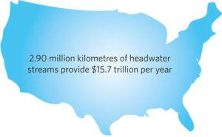
Vulnerable waters are economically valuable (Box 1). An estimate for the conterminous US of ecosystem services provided by headwater streams, including water supply, water purification (for example, via nitrogen transformation and phosphorus sequestration), and climate regulation (for example, via carbon sequestration), indicates an average annual economic value of $14,400 ha–1 yr–1 (2015 USD, here and throughout)19. This value represents an average of $5.40 million km–1 yr–1 and a total of $15.7 trillion yr–1 in ecosystem services for the estimated 2.90 million km of vulnerable streams in the conterminous US and Hawai‘i 20. Similarly, an estimate of ecosystem services from wetlands outside of the floodplain — including water supply, water purification, flood control and recreation — is $102,000 ha–1 yr–1 (ref. 21), yielding an economic value totalling $673 billion yr–1 for the estimated 6.59 million hectares of wetlands outside of floodplains in the conterminous US16. Indeed, a global meta-analysis suggests ecosystem services per unit area are highest from the smallest wetlands22 (Supplementary Section 2). However, the monetized ecosystem service values from vulnerable waters are rarely, if ever, incorporated into the economy.
Box 1: Definition and valuation of vulnerable waters.
Vulnerable waters include headwater streams and wetlands outside of floodplains.
Headwater streams. Headwater streams are defined as small, intermittent streams and creeks that carry water from the upper reaches of a watershed downstream.
Wetlands outside of floodplains. Wetlands outside of floodplains do not have a permanent surface inflow or outflow and are not directly abutting rivers.
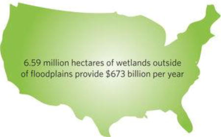
In the US, vulnerable waters provide substantial ecosystem services to society. This valuation of ecosystem services (below) is conservative, as it is based on ecosystem services for which dollar estimates were provided, and is not an exhaustive list Valuation of ecosystem services provided by headwater streams and wetlands outside of floodplains in the US.
It follows, then, that in comparison to other water bodies, vulnerable waters and their functions have been disproportionately degraded or destroyed in response to a variety of human activities23,24. Those waters that remain are increasingly at risk from the cumulative effects of changing climate, land use (for example, urban expansion, agricultural intensification, mining), invasive species and large-scale water withdrawal25. Warmer temperatures and altered precipitation resulting from global climate change — together with increasing commodity prices incentivizing farming on agriculturally marginal lands — are likely to accelerate wetland loss26. These global pressures underscore the urgent need for comprehensive scientific-evidence-based guidance on where, when and how to protect vulnerable waters and their attendant functions.
Enhancing protection of vulnerable waters
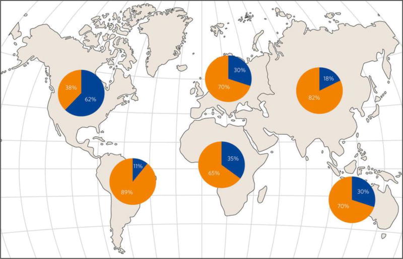
Scientific evidence supports protecting vulnerable waters. An exhaustive synthesis of the peer-reviewed literature determined that all waters in riparian and floodplain areas are physically, chemically and biologically integrated with their river networks14. The synthesis also recognized that many non-floodplain waters, even when lacking apparent surface water connections, nevertheless provide physical, chemical and biological functions that could markedly affect the integrity of downstream waters. Yet, the continued loss of vulnerable waters suggests a gaping disconnect between frequently stated policy goals to protect water resources and resultant policy outcomes. The level of protection being afforded to vulnerable waters is not sufficient to sustainably maintain their functions and attendant ecosystem services. For example, wetland losses across the globe have continued in recent decades (>30% areal losses since 197027; Fig.1), and while estimates do not exist for stream losses, we expect them to be similar given the large-scale human modifications of headwater reaches28–30. Protection policies for vulnerable waters should be grounded in scientific evidence and therefore include floodplain and non-floodplain waters, though we recognize that protection may in fact vary from preservation (that is, no modifications permitted) to wisely managed protection (that is, conservation or loss followed by mitigation).
Figure 1. Estimated loss of wetland areas in different continents of the world.
Estimates of losses in wetland area after 1900 are shown in orange, with remaining wetland area in blue. Human developmental pressures, including urban and agricultural expansion, have resulted in substantive wetland losses across the globe, and climate change has exacerbated wetland loss in some continents. These losses have significant societal consequences, including increased floods, impaired water supplies and loss of biodiversity.
In the US, local, state and tribal governments are required at the least to uphold federal environmental laws and regulations. Recent executive action necessitates additional efforts from these governments to sustainably maintain functions and services provided by vulnerable waters. We propose three scientific-evidence-based strategies that local, state and tribal decision-makers may wisely select to ensure long-term protections for, and benefits from, vulnerable waters. These strategies for effective vulnerable-water management were borne of the emergent uncertainty in the US, and are hence more germane to the system of federalism therein. They are, however, applicable for decision-makers at all levels of government worldwide. The options range from the most protective of vulnerable waters, which requires the fewest resources for monitoring and adaptively managing, to the least protective of vulnerable water extent that will require the greatest expenditure of resources to ensure the provisioning of societally determined functions and services.
A protection strategy (Option 1)
Option 1 protects all vulnerable waters. Scientific evidence suggests that vulnerable waters provide services at local scales and perform important hydrological, biogeochemical and ecological functions at watershed scales14,31. Although destruction of a single wetland or stream reach is unlikely to be detectable or remarkable at the watershed scale, adopters of Option 1 recognize the limits of scientific evidence in determining loss thresholds that may lead to significant changes in watershed functions32,33. For example, scientists are often unable to parsimoniously and precisely ascribe functional contributions of individual vulnerable waters because of the beguiling complexity and varying scales of controlling processes. There is clear scientific rationale to support this option — maintaining vulnerable waters on the landscape maximizes the sustainable delivery of functions and services far into the future. Furthermore, scientific uncertainties associated with selection of this option hinge solely on operational definitions and the inventorying of vulnerable waters. Therefore, societal resources required to enact this option — that is, the the time and money required — are quite limited, though we recognize the opportunity costs to individual landowners may be substantial. In the US, some states have already exercised this option (Supplementary Section 4).
An effects strategy (Option 2)
Scientific evidence suggests that all waters have a substantive and quantifiable connection to other surface waters3 . The cumulative effects of losing vulnerable waters from a watershed are conclusive and remarkable1,19–22,34. However, governments may decide to forego a simple and effective choice in protecting all waters, and instead protect only those vulnerable waters with demonstrable effects to hydrological, chemical and biological integrity of downstream waters. Therefore, Option 2 protects those vulnerable waters with quantifiable effects on downstream waters. The state of the science on available and effective tools to do so (and recommendations for enhancing and integrating these tools in resource management) has been recently reviewed by Golden et al.35. There is great promise for the emergence of practical methods to assess hydrological, chemical and biological effects, including geographic information systems36, remote sensing37, models38,39 and tracers40. However, tools to operationalize Option 2 are generally not yet fully available. Consequently, resource-intensive, site- or watershed-specific determinations are probably the current norm for entities adopting Option 2.
A functions strategy (Option 3)
Scientific evidence has established that vulnerable waters provide an emerging suite or portfolio of functions affecting downstream waters3 . As functional properties of vulnerable waters are increasingly measured, mapped and modelled across regions, the contributions of individual vulnerable waters to cumulative functions will become increasingly quantifiable at the watershed-scale. Therefore, Option 3 protects a portfolio of hydrological, chemical and biological functions that vulnerable waters provide to downstream waters.
The enacted Option 3 enhances long-term protection of most (but not all) vulnerable waters. It identifies and prioritizes sets of vulnerable waters for protection above and beyond federally mandated minimum protections for an evidence-based goal of maintaining a complete portfolio of functions at the watershed scale. This approach may allow loss of some vulnerable waters that are protected under Option 1 or 2, but nonetheless this option protects a set of waters to secure a targeted portfolio of functions. Inherent in the selection of Option 3 is the need to devote substantive resources to quantify relevant functions of individual vulnerable waters within watersheds41, and thence to quantify watershed-scale provisioning of relevant functions by these vulnerable waters. This watershedscale ‘portfolio-of-functions’ approach must be resilient to changing management priorities and decisions. Also, as societies tend to focus on short-term returns at the expense of longer-term benefits, this approach critically requires safeguard measures to ensure thresholds are not crossed that result in undesired system states.
Option 3 hinges on the reality that whereas the loss of a single vulnerable water may well be undetectable, thresholds exist above which cumulative loss or degradation of these waters will have impacts that are probably irreversible. Similarly, certain vulnerable waters may serve as keystones, the existence of which ensures the delivery of myriad functions and ecosystem services. Key to successful implementation of Option 3 is strong adherence to maintaining the complete portfolio of functions provided by vulnerable waters, as well as the implementation and continued development of tools to measure and monitor these functions over time. Therefore, this option requires significant investments for scientists and policymakers to work together to develop these tools. There are jurisdictions that are already moving to adopt this watershed-scale portfolio-of-functions approach in vulnerable water policies42,43.
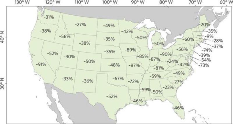
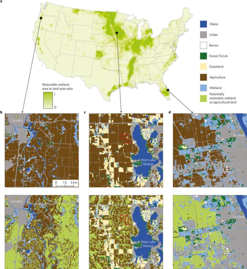
Option 3 can use an integrated approach that considers not only protection but restoration of vulnerable waters. Restoration represents an important management action to regain lost functionality of vulnerable waters, especially wetlands. For example, Fig. 2 presents a map of wetland loss within the US over the past 200 years. Restoration of upland embedded, riparian and floodplain wetlands on agricultural lands — where some of the most easily restorable wetlands that have been ditched, drained or otherwise altered exist — would restore important ecosystem functions and services to the landscape (Fig. 3). Once restored, these once ‘marginal lands’ for agriculture can provide valuable ecosystem services at some level of function44. Restoration does not create vulnerable waters that capture the breadth and diversity of functions at levels equivalent to natural vulnerable waters45. Nevertheless, targeted restoration returns valuable functions and related ecosystem services to the landscape46. For this integrated portfolio approach, one needs to be able to predict the functions of both existing and restorable wetlands, and these types of tools are already being developed47,48.
Figure 2. Percentage loss of wetland area in the continental US from the 1780s to the 1980s (ref. 51).
Figure 3. Wetland restoration provides opportunities to regain wetland functions.
a, Restorable wetland area52. b-d, Land cover (top, ref. 53) and restorable wetlands (bottom, refs 52,53) (scale same for all locations). Left to right: Willamette River Valley south of Corvallis, Oregon (b); West Lake Okoboji, Iowa (c); and St. Lucie, Florida (d). In 2016, a 150 ha wetland-prairie complex restoration (c, red boundaries) was finished to intercept tile drainage and reduce sediment and nutrient loads entering West Lake Okoboji.
Lessons for the US and the world
In the US, the federal government establishes regulations and local, state and tribal entities must at least meet these regulations. Enhanced protection of vulnerable waters — over and above what may be required by federal law — is needed to create a protection floor; that is, the minimum threshold of protection needed to maintain the baseline functions of vulnerable waters. Without such a protection floor, maintaining vulnerable waters will continue to be problematic (for example, Fig. 2). But where should the protection floor be established? Scientific evidence suggests that all vulnerable waters perform important functions and services that accrue at both local and landscape scales and therefore all of the remaining vulnerable waters should be protected under Option 1. However, some local, state and tribal entities, especially those with high levels of remaining vulnerable waters, may understandably choose other options. There are trade-offs that must be addressed across all options listed. Option 1 protects all existing vulnerable waters and thus maintains the breadth of important functions provided by these waters for generations to come. However, opportunity costs accrue if these waters are taken out of consideration for draining, filling or other modifications. Options 2 and 3 allow for restricted loss of vulnerable waters, and so fewer opportunity costs occur. Countering the reduction in opportunity costs, society bears the additional costs under Options 2 and 3 of substantive scientific and technical resources required to identify which vulnerable waters can be developed (that is, quantifying lost ecosystem functions and services from their destruction).
Our focus has been on the US situation, but there are lessons for vulnerable waters that are relevant to other regions of the world (Fig. 1, Supplementary Section 4). In regions with high historic losses of vulnerable waters, Option 1 (protect all remaining vulnerable waters) seems appropriate for protecting the limited vulnerable waters on the landscape. In regions with no or minimal protection of vulnerable waters, Option 3 (protect a functional portfolio of vulnerable waters) may be appropriate as it acknowledges the dual (and sometimes duelling) principles of environmental regulation: balancing protection of the environment on one hand with society’s ability to innovate and create economic opportunities on the other. We see the suite of options transitioning from 1 to 2 to 3 as a set of trade-offs between optimizing protection of the vulnerable waters and an increasing level of required scientific and technical resources35. Ultimately, the optimal option is contextually dependent, though we hasten to add the scientific evidence strongly suggests establishing a minimum protection floor. Vulnerable water protection is critical to maintaining streams and rivers as fishable, swimmable, and drinkable water resources for generations to come. A do-nothing approach, an unheralded ‘Option 4’, would probably result in significant ecosystem degradation. Irrespective of which option governments adopt, scientists around the world need to continue to develop the tools necessary to support policy and management decisions that enhance the protection and restoration of vulnerable waters.
The time for action is now
Gaylord Nelson, founder of Earth Day, said: “The ultimate test of man’s conscience may be his willingness to sacrifice something today for future generations whose words of thanks will not be heard.” Water resource policy modifications such as the CWR are very rare, and have long-term implications. Crucially, federal regulations in the US define minimum regulatory protections; state, tribal and local managers can supplement and enhance federal protections of vulnerable waters where justified for long-term sustainability. Whereas variation among lower jurisdictions will ultimately create de facto adaptive management experiments from which new insights on policy outcomes and trade-offs will emerge, all jurisdictions are charged with decision-making affecting the long-term management of our water commons. The current lack of clarity on the scope of regulations under the CWA provides a timely opportunity for authorities in the US (for example, state, tribal and local) and all levels of governments elsewhere to consider the implementation of policies inspired by a long-term sustainable view of vulnerable waters and the watersheds that they help maintain. The best available scientific evidence provides proof of headwater stream and wetland effects on downstream waters, their role in supporting other important landscape functions, the enormous costs of restoring valuable functions once lost, and prudent precaution in protecting their functions given rapid changes in climate and human development pressure. It is this scientific evidence that compels enhanced protections of vulnerable waters.
Supplementary Material
Acknowledgments
This Perspective arose from a ‘Geographically Isolated Wetlands Research Workshop’ co-hosted by the US Environmental Protection Agency (US EPA) Office of Research and Development, and the Joseph W. Jones Ecological Research Center in Newton, Georgia, 18–21 November, 2013. This Perspective also benefited from discussions held at the ‘Connectivity of Geographically Isolated Wetlands to Downstream Waters’ Working Group supported by the John Wesley Powell Center for Analysis and Synthesis, funded by the US Geological Survey and the US EPA Office of Research and Development, National Exposure Research Laboratory. We acknowledge Rose Kwok of the US EPA Office of Water, for her contributions to the history of the US CWA (Supplementary Section 1) and Brian Hill of the US EPA Office of Research and Development, for his contributions to the data used in the calculation of ecosystem services (Supplementary Section 2). The findings, conclusions and views expressed in this article are those of the authors and do not necessarily reflect the views or policies of the US EPA or the US Fish and Wildlife Service.
References Cited
- 1.Freeman MC, Pringle CM, Jackson CR. Hydrologic connectivity and the contribution of stream headwaters to ecological integrity at regional scales. J. Am. Wat. Resour. Assoc. 2007;43:5–14. [Google Scholar]
- 2.Leigh C, et al. Ecological research and management of intermittent rivers: an historical review and future directions. Freshwater Biol. 2016;61:1181–1199. [Google Scholar]
- 3.Cohen MJ, et al. Do geographically isolated wetlands influence landscape functions? Proc. Natl Acad. Sci. USA. 2016;113:1978–1986. doi: 10.1073/pnas.1512650113. [DOI] [PMC free article] [PubMed] [Google Scholar]
- 4.Shook KR, Pomeroy JW. Memory effects of depressional storage in Northern Prairie hydrology. Hydrol. Process. 2011;25:3890–3898. [Google Scholar]
- 5.Kelleher C, Wagener T, McGlynn B. Model-based analyses of the influence of catchment properties on hydrologic partitioning across five mountain headwater subcatchments. Wat. Resour. Res. 2015;51:4109–4136. doi: 10.1002/2014WR016147. [DOI] [PMC free article] [PubMed] [Google Scholar]
- 6.Tetzlaff D, et al. A preliminary assessment of water partitioning and ecohydrological coupling in northern headwaters using stable isotopes and conceptual runoff models. Hydrol. Process. 2015;29:5153–5173. doi: 10.1002/hyp.10515. [DOI] [PMC free article] [PubMed] [Google Scholar]
- 7.Alexander RB, et al. The role of headwater streams in downstream water quality. J. Am. Water Resour. Assoc. 2007;43:41–59. doi: 10.1111/j.1752-1688.2007.00005.x. [DOI] [PMC free article] [PubMed] [Google Scholar]
- 8.Marton JM, et al. Geographically isolated wetlands are important biogeochemical reactors on the landscape. Bioscience. 2015;65:408–418. [Google Scholar]
- 9.Rains MC, et al. Geographically isolated wetlands are part of the hydrological landscape. Hydrol. Process. 2016;30:153–160. [Google Scholar]
- 10.Kirkman LK, Drew MB, West LT, Blood ER. Ecotone characterization between upland longleaf pine/wiregrass stands and seasonally-ponded isolated wetlands. Wetlands. 1998;18:346–364. [Google Scholar]
- 11.Semlitsch RD, Bodie JR. Are small, isolated wetlands expendable? Conserv. Biol. 1998;12:1129–1133. [Google Scholar]
- 12.Snodgrass JW, Komoroski MJ, Bryan AL, Burger J. Relationships among isolated wetland size, hydroperiod, and amphibian species richness: implications for wetland regulations. Conserv. Biol. 2000;14:414–419. [Google Scholar]
- 13.Finn DS, Bonada N, Múrria C, Hughes JM. Small but mighty: headwaters are vital to stream network biodiversity at two levels of organization. J. N. Am. Benthol. Soc. 2011;30:963–980. [Google Scholar]
- 14.Connectivity of Streams and Wetlands to Downstream Waters: A Review and Synthesis of the Scientific Evidence Technical Report, EPA/600/R-14/475F. US Environmental Protection Agency; 2015. [Google Scholar]
- 15.Olsen AR, Peck DV. Survey design and extent estimates for the Wadeable Streams Assessment. J. North Am. Benthological Soc. 2008;27:822–836. [Google Scholar]
- 16.Lane CR, D’Amico E. Identification of putative geographically isolated wetlands of the conterminous United States. J. Am. Water Resour. Assoc. 2016;52:705–722. [Google Scholar]
- 17.Creed IF, Sanford SE, Beall FD, Molot LA, Dillon PJ. Cryptic wetlands: integrating hidden wetlands in regression models of the export of dissolved organic carbon from forested landscapes. Hydrol. Process. 2003;17:3629–3648. [Google Scholar]
- 18.Bishop K, et al. Aqua Incognita: the unknown headwaters. Hydrol. Process. 2008;22:1239–1242. [Google Scholar]
- 19.Hill BH, Kolka RK, McCormick FH, Starry MA. A synoptic survey of ecosystem services from headwater catchments in the United States. Ecosyst. Serv. 2014;7:106–115. [Google Scholar]
- 20.Nadeau TL, Rains MC. Hydrological connectivity between headwater streams and downstream waters: how science can inform policy. J. Am. Water Resour. Assoc. 2007;43:118–133. [Google Scholar]
- 21.Adusumulli N. Valuation of ecosystem services from wetlands mitigation in the US. Land. 2015;4:182–196. [Google Scholar]
- 22.Ghermandi A, Van Den Bergh JC, Brander LM, de Groot HL, Nunes PA. Values of natural and human-made wetlands: a meta-analysis. Water Resour. Res. 2010;46:W12516. [Google Scholar]
- 23.Beaulieu JJ, et al. Urban stream burial increases watershed-scale nitrate export. PLoS One. 2015;10:e0132256. doi: 10.1371/journal.pone.0132256. [DOI] [PMC free article] [PubMed] [Google Scholar]
- 24.Fritz KM, et al. Comparing the extent and permanence of headwater streams from two field surveys to values from hydrographic databases and maps. J. Am. Water Resour. Assoc. 2013;49:867–882. [Google Scholar]
- 25.Calhoun AJK, et al. Temporary wetlands: challenges and solutions to conserving a ‘disappearing’ ecosystem. Biol. Conserv. 2017;211:3–11. [Google Scholar]
- 26.Millett B, Johnson WC, Guntenspergen G. Climate trends of the North American prairie pothole region 1906–2000. Clim. Change. 2009;93:243–267. [Google Scholar]
- 27.Dixon MJR, et al. Tracking global change in ecosystem area: the Wetland Extent Trends index. Biol. Conserv. 2016;193:27–35. [Google Scholar]
- 28.Acuña V, et al. Why should we care about temporary waterways? Science. 2014;343:1080–1081. doi: 10.1126/science.1246666. [DOI] [PubMed] [Google Scholar]
- 29.Datry T, Larned ST, Tockner K. Intermittent rivers: a challenge for freshwater ecology. BioScience. 2014;64:229–235. [Google Scholar]
- 30.Acuña V, Hunter M, Ruhl A. Managing temporary streams and rivers as unique rather than second-class ecosystems. Biol. Conserv. 2017;211:12–19. [Google Scholar]
- 31.Bedford BL. Cumulative effects on wetland landscapes: links to wetland restoration in the United States and southern Canada. Wetlands. 1999;19:775–788. [Google Scholar]
- 32.Carpenter SR, et al. Early warnings of regime shifts: a whole-ecosystem experiment. Science. 2011;332:1079–1082. doi: 10.1126/science.1203672. [DOI] [PubMed] [Google Scholar]
- 33.Capon SJ, et al. Regime shifts, thresholds and multiple stable states in freshwater ecosystems; a critical appraisal of the evidence. Sci. Total Environ. 2015;534:122–130. doi: 10.1016/j.scitotenv.2015.02.045. [DOI] [PubMed] [Google Scholar]
- 34.Van Meter KJ, Basu NB. Signatures of human impact: size distributions and spatial organization of wetlands in the Prairie Pothole landscape. Ecol. Appl. 2015;25:451–465. doi: 10.1890/14-0662.1. [DOI] [PubMed] [Google Scholar]
- 35.Golden HE, et al. Integrating geographically isolated wetlands into land management decisions. Front. Ecol. Environ. 2017 doi: 10.1002/fee.1504. [DOI] [PMC free article] [PubMed]
- 36.Uden DR, Hellman ML, Angeler DG, Allen CR. The role of reserves and anthropogenic habitats for functional connectivity and resilience of ephemeral wetlands. Ecol. Appl. 2014;24:1569–1582. doi: 10.1890/13-1755.1. [DOI] [PubMed] [Google Scholar]
- 37.Vanderhoof MK, Alexander LC, Todd JM. Temporal and spatial patterns of wetland extent influence variability of surface water connectivity in the Prairie Pothole Region, United States. Landscape Ecol. 2016;31:805–824. [Google Scholar]
- 38.Evenson GR, Golden HE, Lane CR, D’Amico E. An improved representation of geographically isolated wetlands in a watershed-scale hydrologic model. Hydrol. Process. 2016;30:4168–4184. [Google Scholar]
- 39.Ameli AA, Creed IF. Quantifying hydrologic connectivity of wetlands to surface water systems. Hydrol. Earth Syst. Sci. 2017;21:1791–1808. [Google Scholar]
- 40.McDonnell JJ, Beven K. Debates—the future of hydrological sciences: a (common) path forward? A call to action aimed at understanding velocities, celerities and residence time distributions of the headwater hydrograph. Wat. Resour. Res. 2014;50:5342–5350. [Google Scholar]
- 41.Smith RD, Ammann A, Bartoldus C, Brinson MM. An Approach for Assessing Wetland Functions Using Hydrogeomorphic Classification, Reference Wetlands, and Functional Indices. US Army Corps of Engineers; 1995. [Google Scholar]
- 42.Alberta Wetland Policy (Edmonton, Alberta) Government of Alberta; 2013. [Google Scholar]
- 43.Creed IF, Aldred DA, Serran JN, Accatino F. In: Wetland and Stream Rapid Assessments: Development, Validation, and Application. Dorney J, Savage R, Tiner R, Adamus P, editors. Elsevier; in the press. [Google Scholar]
- 44.Moreno-Mateos D, Power ME, Comín FA, Yockteng R. Structural and functional loss in restored wetland ecosystems. PLoS Biol. 2012 doi: 10.1371/journal.pbio.1001247. [DOI] [PMC free article] [PubMed]
- 45.Ehrenfeld JG. Defining the limits of restoration: the need for realistic goals. Restoration Ecol. 2000;8:2–9. [Google Scholar]
- 46.Groot RS, et al. Benefits of investing in ecosystem restoration. Conserv. Biol. 2013;27:1286–1293. doi: 10.1111/cobi.12158. [DOI] [PubMed] [Google Scholar]
- 47.Wang X, et al. Simulated wetland conservation-restoration effects on water quantity and quality at watershed scale. J. Environ. Manage. 2010;91:1511–1525. doi: 10.1016/j.jenvman.2010.02.023. [DOI] [PubMed] [Google Scholar]
- 48.Darwiche-Criado N, et al. Effects of wetland restoration on nitrate removal in an irrigated agricultural area: the role of in-stream and off-stream wetlands. Ecol. Eng. 2017;103:426–435. [Google Scholar]
- 49.Junk WJ, et al. Current state of knowledge regarding the world’s wetlands and their future under global climate change: a synthesis. Aquat. Sci. 2013;75:151–167. [Google Scholar]
- 50.Davidson NC. How much wetland has the world lost? Long-term and recent trends in global wetland area. Mar. Freshwater Res. 2014;65:934–941. [Google Scholar]
- 51.Dahl TE. Wetland losses in the United States 1780s to 1980s. US Department of the Interior, Fish and Wildlife Service; 1990. [Google Scholar]
- 52.Environmental Dataset Gateway. US Environmental Protection Agency; [accessed 28 June 2017]. ftp://newftp.epa.gov/epadatacommons/ORD/ EnviroAtlas/PRWAg.zip. [Google Scholar]
- 53.Homer C, et al. Completion of the 2011 national land cover database for the conterminous United States — representing a decade of land cover change information. Photogramm. Eng. Remote Sens. 2015;81:345–354. [Google Scholar]
Associated Data
This section collects any data citations, data availability statements, or supplementary materials included in this article.


