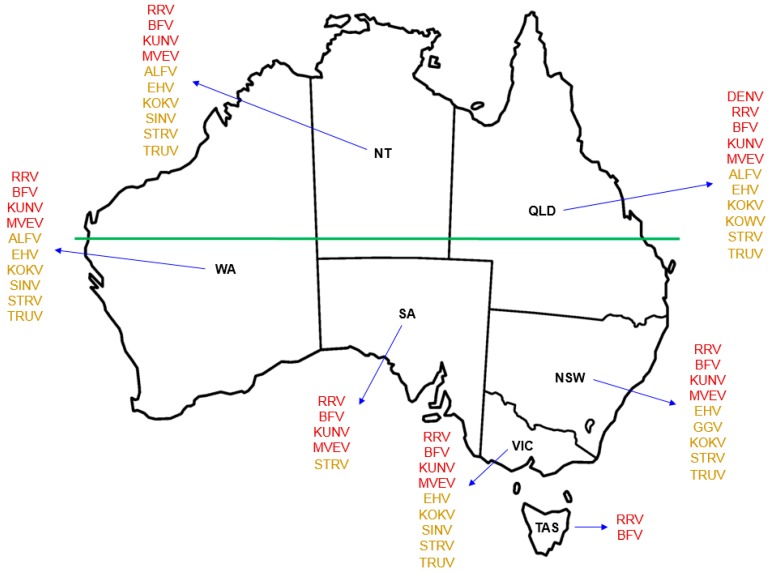
Figure 1.
Geographical distribution of Australian indigenous arboviruses known to cause human infection. Use of red font for each named virus indicates the state or territory from which that virus is known to be recovered and the notifiable disease for which it is listed in the Australian National Notifiable Disease Surveillance System (ANNDSS). Use of amber font for each named virus indicates the reported recovery of that virus from mosquitoes during mosquito surveillance but that the corresponding virus-associated disease is not currently recorded in the ANNDSS. Named arboviruses: ALFV—Alfuy; BFV—Barmah Forest; DENV—Dengue; EHV—Edge Hill; GGV—Gan Gan; KOKV—Kokobera; KOWV—Kowanyama; KUNV—Kunjin; MVEV—Murray Valley encephalitis; RRV—Ross River; SINV—Sindbis; STRV—Stratford; Trubanaman—TRUV. The land mass above the horizontal green line, which marks the southern edge of the Pilbara Range (latitude 24° S, just south of the Tropic of Capricorn, 23.52° S), approximates to the region termed Northern Australia. States and territory: NSW—New South Wales; NT—Northern Territory; QLD—Queensland; SA—South Australia; TAS—Tasmania; VIC—Victoria; WA—Western Australia.

