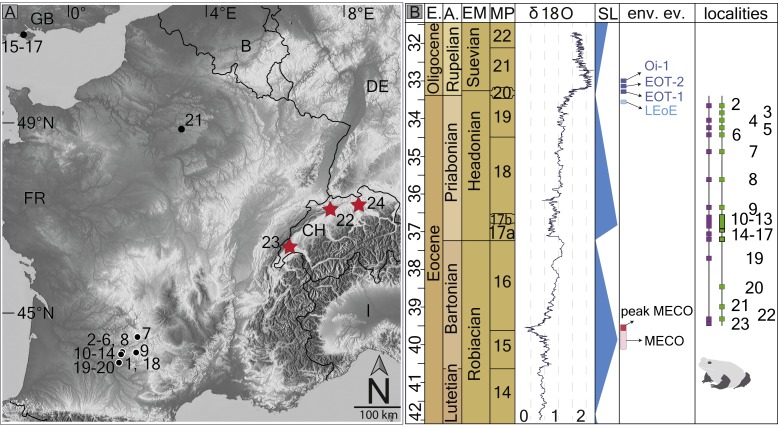
Figure 1. Fossil record of the genus Thaumastosaurus.
(A) Geographic distribution of the localities (see below) with the Thaumastosaurus record (see more in Table S1). (B) Stratigraphic distribution of the localities indicated in (A), accompanied by curve of the δ18O development and sea level changes according to Vandenberghe, Hilgen & Speijer (2012), important environmental events (e.g., MECO, Oi–1) during the late Eocene and early Oligocene (Coxall & Wilson, 2011; Boscolo Galazzo et al., 2014), as well as the fossil record of the genus Thaumastosaurus and Eocene Ranidae/Rana sp./? Rana sp. (see more in Table S1). The heading abbreviation in (B) as follows: E, epoch; A, age; EM, European Land Mammal ages; MP, European Palaeogene Mammal Reference Level; SL, sea level; env. ev., environmental events; pk MECO/MECO, peak of/Mid–Eocene climatic optimum; LEoE, Late Eocene glaciation event; EOT–1, Eocene–Oligocene Transition event 1; EOT–2, Eocene–Oligocene Transition event 2, Oi–1, Oligocene 1 glacial maximum. The numbers correspond to the localities as following: 1, Quercy Phosphorite; 2, Escamps; 3, Rosières 1; 4, Coânac 1; 5, Rosières 2; 6, Sindou D; 7, Sainte–Néboule; 8, Monteils; 9, Cregols; 10, Perrière; 11, Malpérié; 12, Aubrelong 2; 13, La Bouffie; 14, Lebratières 1; 15, Southwest Headon Hill (=Headon Hill 3); 16, Rodent bed, Hordle Cliff locality; 17, Mammal bed, Hordle Cliff locality; 18, Quercy Phosphorite; 19, Le Bretou; 20, Lavergne; 21, Grisolles; 22, Verrerie de Roches; 23, Les Alleveys; 24, Dielsdorf. The localities 1 and 18 Quercy Phosphorite as well as 24, Dielsdorf (Table S1) are not included into the row “taxa occurrences” due to the age inaccuracy. Map data © OpenStreetMap contributors, CC BY-SA.

