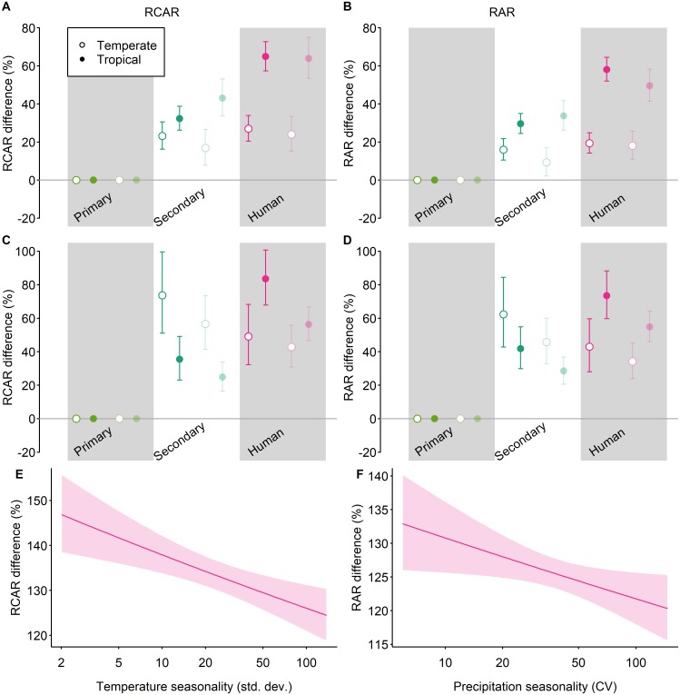
Fig 3. Geographical variation in the response of RCAR to land use.
We first tested for tropical-temperate differences in observed responses to disturbed land uses (A–D), and then whether responses to human land use vary with climatic seasonality or topographic heterogeneity (significant results are shown in E–F). All effects are shown as a percentage difference from values in primary vegetation. Error bars (A–D) and shading around lines (E–F) show 95% confidence intervals. For the analyses shown here, the land-use classification was coarsened to 3 classes: primary vegetation, secondary vegetation (all stages of recovery), and human-dominated (plantation forest, cropland, pasture, and urban). Land-use intensity was not considered. For the tropical-temperate models (A–D), as in the main models, we considered 3 measures of range size, with community-average range size both weighted (RCAR; A, C, and E) and unweighted (RAR; B, D, and F) by species’ abundance; these different combinations are plotted as in Fig 2. The site-level data underlying the models shown here are freely available (DOI: 10.6084/m9.figshare.7262732). CV, Coefficient of variation; RAR, Relative Average Range Size; RCAR, Relative Community Average Range Size.

