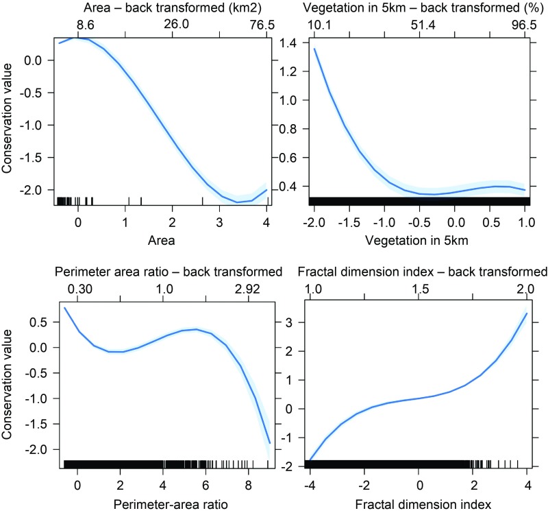
Fig. 1.
Relationship between conservation value (logit-transformed) and the four patch-level independent variables from the global model. Independent variables presented are patch area, proportion of cells containing natural vegetation in a 5-km radius, the fractal dimension of the habitat patch, and the perimeter−area ratio of the patch in which the cell is located. The x axes along the bottom of the plots give standardized values of independent variables used in the regression. Equivalent raw values are given on the upper x axes. The conservation value of a landscape unit (a single raster cell) is defined by its conservation importance rank, as determined by a Zonation analysis (y axis), that takes into account the proportion of species’ ranges contained within each cell. Cells with a high conservation rank will tend to be ones that constitute a larger proportion of the remaining range of a species. Zonation conservation values that range on the scale [0,1] were logit-transformed to allow linear modeling (43). All independent variables were standardized, so the scale on the x axes represents SDs from the mean. Each of the relationships depicted here were statistically significant at P < 0.01. Each of the independent variables was fitted as a cubic polynomial. An interaction between patch area and fractal dimension was included in the AIC-best model (SI Appendix, section S2). An autocovariate term was fitted to reduce spatial autocorrelation in model residuals (see SI Appendix, section S2 for details).

