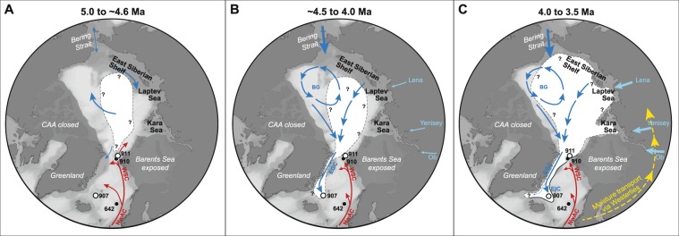
Figure 3.
Schematic illustration of sea ice extent in the Arctic Ocean and Iceland Sea during the Pliocene. Warm water surface currents (red): NwAC = Norwegian Atlantic Current, WSC = West Spitsbergen Current. Cool water surface currents (blue): BG = Beaufort gyre, EGC = East Greenland Current, EIC = East Icelandic Current. (A) Sea ice (white shaded area) was most likely restricted to the central Arctic Ocean between 5.0 and ~4.6 Ma (e.g. ref.11), while Atlantic waters extended into the Iceland Sea (Site 907). (B) Seasonal sea ice or sea ice transported with the EGC first appear in the Iceland Sea around 4.5 Ma. The Yermak Plateau was sea ice free11, although occasional sea ice may have occurred. (C) Sea ice expanded across the Arctic Ocean56,57 and established a seasonal/extended sea ice cover on the Yermak Plateau and an extended sea ice cover or possibly a sea ice edge (solid line at edge of white shaded area) in the Iceland Sea. This occurred contemporaneous with increased northward heat transport in the eastern North Atlantic and Norwegian Sea. The northward heat transport also brought moisture that was transported via the westerlies (yellow arrows) towards Eurasia where increased freshwater outflow through the Eurasian rivers (light blue arrows) led to freshening of the Arctic Ocean, which favors sea ice formation. Maps were generated with Ocean Data View54.

