Figure 3.
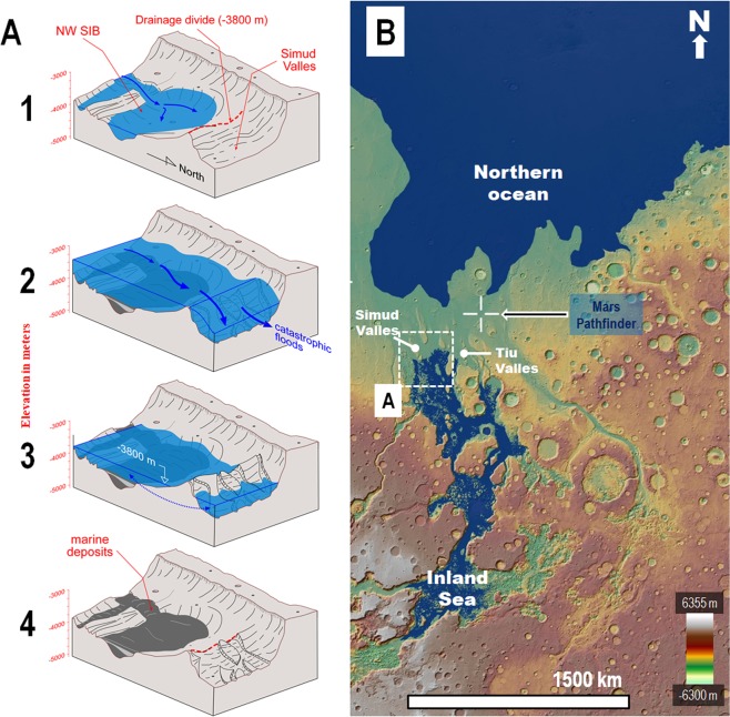
(A) Perspective sketches depicting the paleohydrological reconstruction of the SIB’s northwestern part and adjoining areas of Simud Valles. Panel (B) shows the sketched region’s context and location. Notice that the north direction is towards the bottom right. (1) View of an inland sea margin within the northwestern part of the SIB produced by the progressive impoundment of cataclysmic floods below the drainage divide at the −3,800 m elevation separating the basin and Simud Valles. (2) Floods propagating over the sea produce spillover marine discharges onto Simud and Tiu Valles, which reach the Pathfinder landing site and produce an ocean within the northern plains. (3) Following the cataclysmic floods, an inland sea and a northern plains ocean form. Both marine bodies share the same upper shoreline levels at the −3,800 m elevation, indicating the presence of an interconnected groundwater table at that time (double-headed arrow). (4) Extensive marine sedimentary deposits, with an upper distribution limited by the drainage divide, are left behind within the SIB following the sea’s disappearance. (B) Paleogeographic reconstruction including the two marine bodies formed after the cataclysmic floods (#3 in Panel A). The Pathfinder landing site (crosshair symbol) is located on an enormous spillway that connected the inland sea and the northern ocean. The blue mask over the digital elevation model corresponds to the reconstructed extents of the inland sea and the northern plains ocean. The base map is a MOLA digital elevation model (460 m/pixel) centered at 5°31′17″N, 30°51′24″W. Credit: MOLA Science Team, MSS, JPL, NASA.

