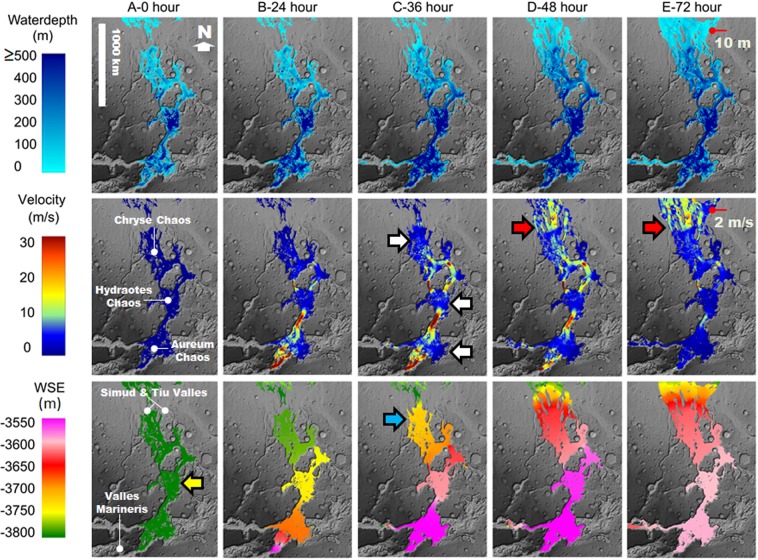
Figure 4.
Numerical simulation of a cataclysmic flooding event from eastern VM13 into the proposed inland sea. The simulation shows the water depths, velocities, and water surface elevations (WSEs) that developed within the inland sea region and adjoining Simud and Tiu Valles during 72 hours following the cataclysmic flood event. Row A (0 hours) shows an inland sea with a surface elevation at −3,800 m (yellow arrow) covering the SIB. Our modeling assumes that this sea existed at the initiation of the cataclysmic flood event. The simulation shows WSE northwards reductions in the 24, 36, 48, and 72-hour time steps. By the 36-hour mark, relatively low depth floods propagating over the SIB’s northern areas (blue arrow) would have produced marine spillover floods into Simud Valles. The SIB’s spillover discharges would have expanded onto Tiu Valles by the 48- and 72-hour marks. The white arrows identify broad zones of flood deceleration, mostly located within Aureum, Hydraotes, and Chryse Chaos. By the 72-hour mark, the floods reached the Pathfinder landing site. The red arrows show abrupt velocity gains as the floods exited the inland sea as vast marine spillover floods. The red pointers indicate the location of the Pathfinder landing site. Our results indicate that at the landing site, the depth and velocity of the floods were 10 m and 2 m/s, respectively. These depth and velocity values are close matches to those estimated in Smith et al.2. The simulation was generated using a river flood model (the Martian HEC-RAS 5.0.3). The simulation’s base map is a MOLA-DEM (460 m/pixel) shaded relief. Credit: MOLA Science Team, MSS, JPL, NASA. The subsided plateaus in the Aureum Chaos region show no evidence of overflow erosion, indicating that subsidence was subsequent to the sea’s formation (Fig. S7)55,62. Consequently, we corrected the DEM at the contact between this chaotic terrain and the margin of the inland sea by creating a flow barrier (Fig. S7).

