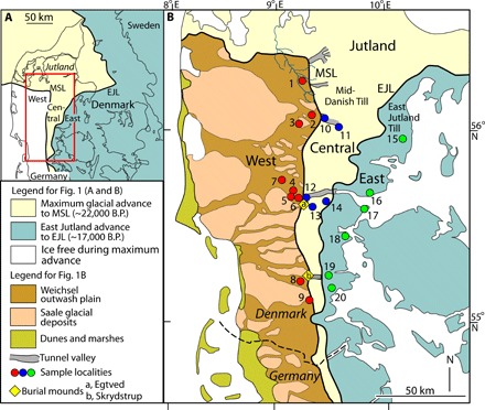
Fig. 1. Simplified Quaternary geological maps of Denmark with sample localities.

(A) Map showing the position of the MSL and the EJL, indicating the maximum extent of the Weichselian ice sheet in Denmark and the maximum advance of the East Jutland Till, respectively. The red rectangle marks the geographic location of the map in (B). (B) The MSL and EJL subdivide Jutland into three glaciogenic provinces: West Jutland (West), Central Jutland (Central), and East Jutland (East). The distribution is indicated in West Jutland of “Hill Islands” (Saale glacial deposits) and Weichsel outwash plains. Sample localities 1 to 20 are marked. Red dots denote samples obtained in West Jutland, blue dots denote those in Central Jutland, and green dots denote those in East Jutland. Maps are based on (17, 18). B.P., before the present.
