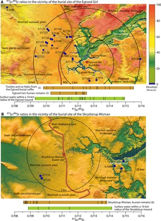
Fig. 6. Main landscape elements and 87Sr/86Sr ratios for lakes, ponds, and springs near the burial mounds of the Egtved Girl and the Skrydstrup Woman.

(A and B) Topographical maps with the locations of the two burial mounds marked with red dots. Only water samples regarded as pristine are shown. Circles with 5- and 10-km radii centered on the burial mounds are indicated. For ponds that have been analyzed twice during the fall of 2018, only the first analysis is shown. The range in the 87Sr/86Sr ratio is shown as bars below the maps together with data obtained from the Egtved Girl (5) and the Skrydstrup Woman (6). All results are listed in table S1 and shown in fig. S2. Maps are based on data from “Styrelsen for Dataforsyning og Effektivisering, skærmkortet, WMS-tjeneste.” m a.s.l., meters above sea level.
