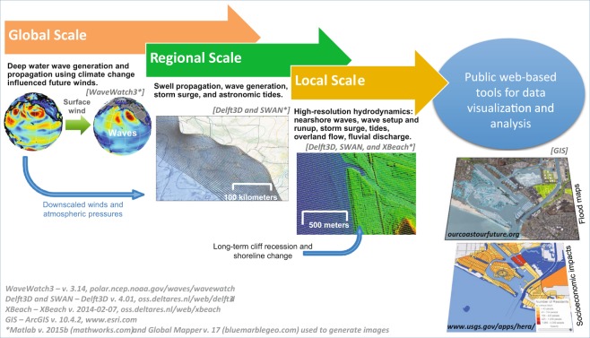
Figure 2.
Coastal Storm Modeling System (CoSMoS) workflow. CoSMoS features a series of coupled numerical models that translates the physical forcing derived from Global Climate Models into local coastal flood projections, incorporating sea level rise, tides, seasonal effects, storm surge, fluvial discharge, and waves, as well as short- and long-term coastal change. The hybrid numerical-statistical model is used to develop continuous time-series of total water levels at the shore using a linear superposition of wave runup (maximum excursion that waves reach onshore), storm surge, and sea levels, in contrast to the numerically modeled flood maps which simulate non-linear interactions between changing water depths and waves. For more information on the CoSMoS framework see the Methods section and Supplementary Fig. 1. Figure modified from O’Neill et al.61. Software citations: WaveWatch3 – v. 3.14, polar.ncep.noaa.gov/waves/wavewatch; Delft3D and SWAN – Delft3D v. 4.01, oss.deltares.nl/web/delft3d with Matlab v. 2015b (mathworks.com) and Global Mapper v. 17 (bluemarblegeo.com) used to generate images.

