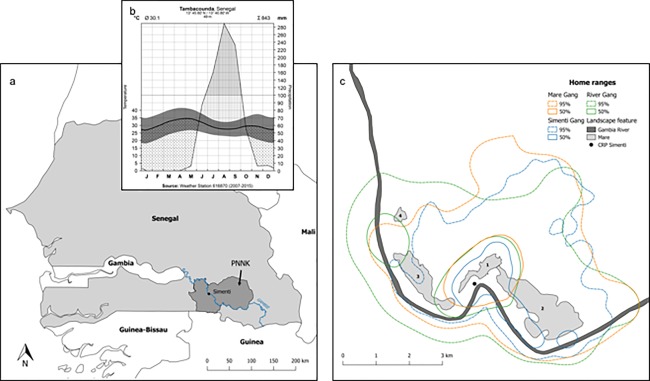
Figure 2.

(a) Map of Senegal with the location of the Niokolo Koba National Park. The field site CRP Simenti lies next to the Gambia river (b). Hygrothermic climograph of the Tambacounda region according to Walter and Lieth (1967). Depicted are monthly temperatures (mean, min, max) in relation to monthly precipitation. Based on the assumed dependency between evaporation and temperature (e.g., monthly Ø 10 °C evaporates 20 mm, and Ø 20 °C evaporates 40 mm), the climograph demarcates periods of aridity, i.e., dry season and humidity, i.e. wet season. Meteorological data was recorded at the Tambacounda Weather Station (ID: GHCND:SG000061687) and derived from the National Oceanic and Atmospheric Administration (NOAA; http://www.ncdc.noaa.gov/cdo-web/). (c) Home range overlap of three of the study gangs at Simenti. Location data was collected by means of GPS‐enabled collars over a three‐year period (2010–2012). Kernel home ranges (fixed KDE) were modeled using the rule‐based ad‐hoc method (Kie, 2013). Dashed lines depict the home ranges (95% contour) and solid lines the core areas (50% contour). The numbers represent the most important wetlands (Mare) in our study region: (1) Mare Simenti, (2) temporary Mare, (3) Mare Kountadala, (4) Mare Nanaka
