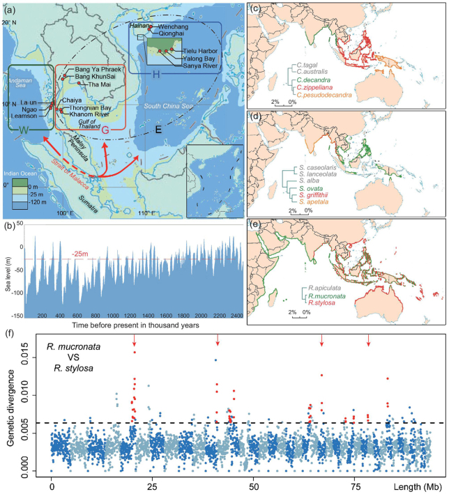
Figure 1.
Geography and patterns of speciation in the Indo-Western Pacific. (a) Population samples were collected from both the Indian and Pacific Ocean coasts, separated by the Strait of Malacca. Red dots mark sampling sites; H, Hainan Island; G, Gulf of Thailand; W, West coast of Thailand. E stands for H + G to the East of the Strait. The red arrow-headed line depicts ocean current (and potential gene flow) through the Strait of Malacca between the Indian and Pacific coasts. (b) Sea-level changes in the last 2.5 Myrs. The red line marks the depth of the Strait of Malacca (–25 meters). (c) Ceriops; (d) Sonneratia; (e) Rhizophora. The species distribution of each genus is based on Mangrove ID [33]. Species pairs delineated by the Strait of Malacca are shown in red and green, while the phylogeny is given in the inset. Additional species boundaries are given in Supplementary Fig. 1, available as Supplementary Data at NSR online. (f) Genetic divergence in 50-Kb sliding windows across the genome between R. mucronata and R. stylosa. Alternating colors denote different scaffolds; the dotted horizontal line marks the highest 5th-percentile in divergence. Red points indicate peaks of consecutive windows with elevated divergence (≥100 Kb). The four red arrows indicate divergence peaks that remain after controlling for mutation rate variation, as scaled by the divergence between R. apiculata and R. mucronata.

