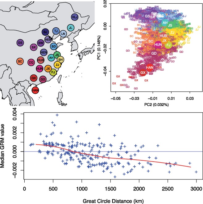
Fig. 1.
Population structure of Han Chinese. (Top Left) The geographical locations of each province of China represented in the data set, with the following abbreviations: AH, Anhui; BJ, Beijing; CQ, Chongqing; FJ, Fujian; GS, Gansu; GD, Guangdong; GX, Guangxi; HAN, Hainan; HEB, Hebei; HLJ, Heilongjiang; HEN, Henan; HUB, Hubei; HUN, Hunan; JS, Jiangsu; JX, Jiangxi; JL, Jilin; LN, Liaoning; SX, Shaanxi; SD, Shandong; SH, Shanghai; SW, Shanxi; SC, Sichuan; TJ, Tianjin; ZJ, Zhejiang. Beijing, Chongqing, Shanghai, and Tianjin are the four metropolitan municipalities of China; the remaining represents 19 out of the 22 provinces and 1 out of 5 autonomous regions of China. (Top Right) The first two PCs showing the North–South structure on PC1 and East–West structure on PC2. Individual labels were assigned based on their self-reported birth locations and colored according to the map on the left. Individuals from the four municipalities were not plotted. (Bottom) Observed decay of genetic relatedness as function of geographical distance, which is consistent with an isolation-by-distance model.

