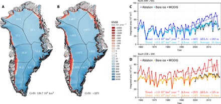
Fig. 3. Rapid ablation zone expansion enhances runoff contribution from north Greenland.

(A) Map of SMB averaged for the period 1958–1990. Numbers refer to the ablation zone area for individual sectors (103 km2) and for the whole GrIS (bottom right). (B) Same as (A) for the period 1991–2017. Numbers refer to the relative ablation zone expansion (%) post-1990 for individual sectors and for the whole GrIS (bottom right). Time series of annual mean modeled ablation zone and summer bare ice area for (C) North Greenland (blue and cyan; i.e., NW + NO) and (D) South Greenland (red and orange; i.e., CW + SW sectors) over the period 1958–2017 compared to MODIS (black) bare ice area estimates (2000–2018). Dashed lines show the 1991–2017 trends. Numbers include trends, relative ablation/bare ice zone expansion, and change in ELA (i.e., SMB = 0) post-1990. In North and South Greenland, the modeled bare ice area is averaged over 10 and 5 days, respectively (see Materials and Methods). The cyan and yellow belt in (C) and (D) represents 1 SD of the 10 and 5 days used to estimate the modeled maximum bare ice area in North and South Greenland, respectively. The gray belt in (C) and (D) shows the uncertainty in measured MODIS bare ice area (see Eq. 1 in Materials and Methods).
