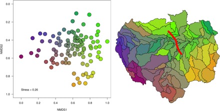
Fig. 3. Composition of freshwater fishes for the 97 Amazonian subdrainage basins inferred from nonmetric multidimensional scaling ordination using a dissimilarity matrix based on the Simpson's dissimilarity index (βsim), a measure of spatial turnover of species composition without the influence of richness gradients.

Colors on the map reflect the corresponding point position along both nonmetric multidimensional scaling (NMDS) axes. The analysis depicts stronger dissimilarities in fauna’s composition for the most southeastern part (yellow shades) of the Amazon and the most westerly Andean end (purple and pink shades) compared to the rest of the Basin. The most southeastern part is mainly represented by the Xingu and Tapajós rivers, both hosting a relatively high number of highland endemic species, i.e., 27 endemic species having a geographical distribution restricted above the 300-m elevation. The most westerly Andean end is mainly represented by the Ucayali and Marañón rivers in Peruvian Amazonia and hosts, as for the most southeastern part of the basin, a high number of highland endemic species, i.e., 28 endemic species having a geographical distribution restricted above the 300-m elevation. The red line in the figure at the right indicates the delimitation of the Purus Arch. According to our data, sub-basins located upstream of the Purus Arch (i.e., belonging to the historical Pebas system; fig. S3) currently cover 64% of the total surface area of the entire Amazon basin and host 86% of its total richness (with two families, 72 genera, and 709 species found exclusively in this area), while sub-basins located downstream of the Arch cover only 36% of the total surface and host 68% of the total richness of the basin (with two families, 46 genera, and 313 species found exclusively in this area).
