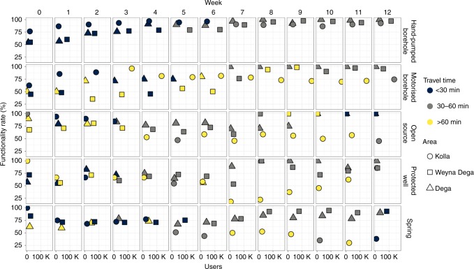
Fig. 7. Summary of functionality, user numbers and travel times by water source type and altitude zone.
The position of the points in the individual panels represent the functionality and overall user numbers for each water source type (a total of ~830,000 people relied on the water sources included in the monitoring programme), colours represent modal travel times for water collection and shapes represent altitude areas. The evolution of the performance of each water source type (in terms of functionality, access and usage) reveals five key points. (1). Hand-pumped boreholes experienced the most consistent overall increases in functionality in all areas and most users travelled for <60 min for water collection (in the first 6 weeks <30 min). (2) Motorised borehole performance was more variable with very low functionality in the Weyna Dega (<50%) and many users having to travel for >60 min to access water throughout the intervention period. (3) In general hand-pumped and motorised boreholes, which accessed deep groundwater (>30 m), were a very important water source for many people during the drought and provided water to ~400,000 people; hand-pumps provided for >100,000 people in the Weyna Dega. Motorised boreholes provided for ~150,000 people in the Kolla. (4) Springs performed reasonably well in the Weyna Dega and Dega areas providing water (travel times < 60 min) to ~100,000 people in the Weyna Dega. Springs were also an important and accessible form of water supply to Kolla communities early in the drought but experienced large declines in functionality from week 6 onwards. (5) Open sources and protected wells experienced large declines in functionality in the Kolla areas but increased functionality in the Weyna Dega and Dega towards the end of the drought period associated with local rainfall.

