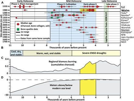
Fig. 2. Chronologies for human settlement in the New Guinea highlands modeled against climate, biomass burning, and relative sea levels.

(A) Calibrated AMS charcoal dates from Waim, Kuk agricultural phases 1 to 3, and other mid-Holocene highland sites (>1200 m asl) in New Guinea. (B) General trends in New Guinea climate based on paleocore data (6). (C) Regional biomass burning based on cumulative charcoal records from Papua New Guinea and Indonesia (6). Scale is standardized cumulative charcoal divided by the number of sites from 200-year temporal periods based on age-depth 14C curves. (D) Sea levels in the New Guinea region over time (43). Yellow shading in (A), (C), and (D) indicates major phase of cultural deposition at Waim. Archaeological sites with evidence for cultivation but no contemporary evidence for mid-Holocene domestic occupation are underlined. *Rockshelter sites. Figure credit: Ben Shaw, UNSW.
