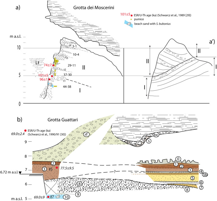
Figure 2.
(a, a′) Stratigraphic sketches of Grotta dei Moscerini redrawn by F. Marra based on unpublished field drawings by A. Segre stored at the IsIPU Repository (Anagni, FR, Italy). Legend: Lt, lithodomus burrows; t, talus layer; layer numbering 1–44 according to unpublished stratigraphy by Aldo Segre synthesized in31. (b) Stratigraphic sketch of Grotta Guattari based on new field work performed for the present study; drawing by F. Marra. Legend: rf—rockfall; bc—cemented conglomerate with mollusk shell fragments; s—grey, femic sand filling the fractures in bc; 0—encrusted rockfall; 1—earthy deposits with small rock fragments; 2—dark brown to dark reddish (outer section), pedogenized sand; 3—brown to reddish (outer section) medium sand; 4—cm-thick carbonatic crust; 5b—slightly pedogenized layer; 5—dark yellow sand, with carbonatic concretions and rare, minute, well rounded gravel (outer section); 6—grey sand; 7—reddened coarse sand with rare, well rounded pebbles; 8—cemented, rounded carbonatic blocks in coarse sand matrix; 9—dark brown, loose sandy deposit; 10—biodetritic sandy conglomerate. Black triangle—GPS measured elevation. See text for explanations.

