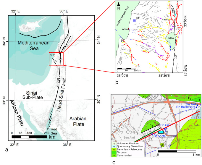
Fig 1. Tectonic setting of study area.
(a) General map showing the main tectonic features in the eastern Mediterranean. SoG—Sea of Galilee. CF—Carmel fault. DSB—Dead Sea basin. Red dot marks the location of Tel Kabri. Reprinted from [21] under a CC BY license, with permission from [Copernicus Publications], original copyright [2019]. (b) Compiled map of faults in the Galilee area. Thin black lines indicate faults that appear on the 1:200000 geological map (Reprinted from [22] under a CC BY license, with permission from [Geological Survey of Israel], original copyright [1998]). Colored lines mark Quaternary faults (Reprinted from [23] under a CC BY license, with permission from [Geological Survey of Israel], original copyright [2018]): Red—evidence of Quaternary activity; Yellow—marginal faults and main branches; Purple—> 6km segments associated with recent activity; Blue dashed—inferred/subsurface; Thick black—Main strike-slip segments of the Dead Sea fault (DSF). Blue square marks location of geological map shown in Fig 1c. SoG—Sea of Galilee. CF—Carmel fault. KF—Kabri fault. Red circle marks the location of Acco, while the yellow circle marks the ancient city of Hazor. (c) Geological map of the area (Reprinted from [22] under a CC BY license, with permission from [Geological Survey of Israel], original copyright [1998]) showing the mound of Tel Kabri and its associated potentially active tectonic fault. Colored lines mark different interpretations for the Kabri fault: black line after [22]; green line after [24]; red line after [25]. Blue dots mark the location of the four springs located in the vicinity of Tel Kabri. Light blue rectangle marks the location of the study area shown in Fig 2.

