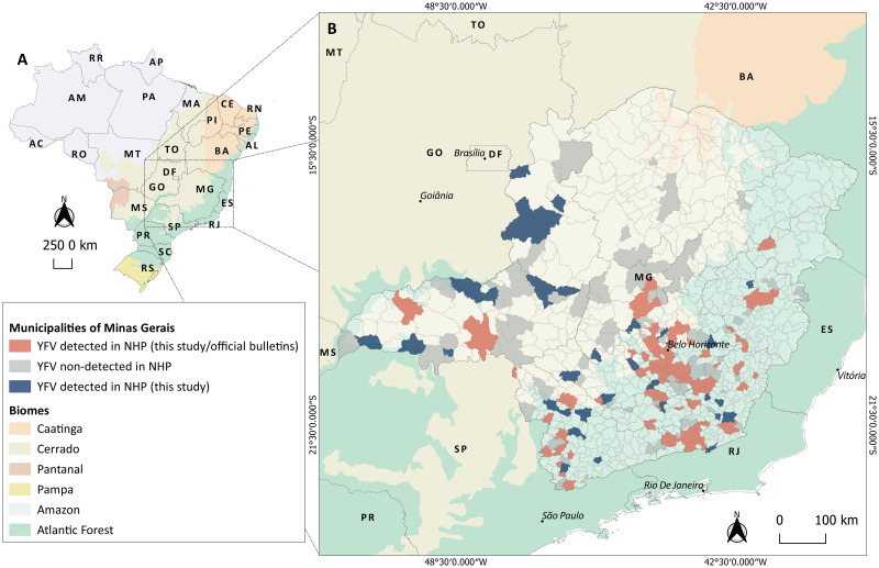
Fig 1. Yellow fever virus (YFV) investigation in non-human primate (NHP) carcasses, in Minas Gerais state, January 2017-December 2018.
(A) Geopolitical map of Brazil with biomes distribution. (B) Map of Minas Gerais state indicating municipalities from where NHP carcasses were collected and investigated for YFV RNA. Municipalities are colored as follows: in grey are 120 municipalities without detection of YFV in NHP (in this study); in light red are 110 municipalities with detection of YFV in NHP (this study and official bulletins); and in blue are 49 municipalities with detection of YFV in NHP (only in this study) where YFV circulation has not been described, during 2016–2018 outbreaks. Based on official bulletins, YFV was detected (humans or NHP) in another 31 municipalities of Minas Gerais by the State Surveillance Secretary during 2016–2018 outbreaks [13,21,22]. Abbreviations referring to Federal District and states as follows: AC: Acre; AL: Alagoas; AP: Amapá; AM: Amazonas; BA: Bahia; CE: Ceará; DF: Distrito Federal; ES: Espírito Santo; GO: Goiás; MA: Maranhão; MT: Mato Grosso; MS: Mato Grosso do Sul; MG: Minas Gerais; PA: Pará; PB: Paraíba; PR: Paraná; PE: Pernambuco; PI: Piauí; RR: Roraima; RO: Rondônia; RJ: Rio de Janeiro; RN: Rio Grande do Norte; RS: Rio Grande do Sul; SC: Santa Catarina; SP: São Paulo; SE: Sergipe; and TO: Tocantins. Numbers indicate the mesoregions of Minas Gerais as follows: 1. Triângulo Mineiro e Alto Paranaíba; 2. Northwest; 3. North; 4. Jequitinhonha; 5. Vale do Mucuri; 6. Vale do Rio Doce; 7. Zona da Mata; 8. South/Southwest; 9. West; 10. Central; 11. Metropolitan region; 12. Campo das Vertentes. Maps were created using the QGIS software version 3.8.2.

