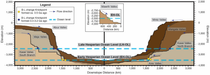
Figure 3.
Representation of the longitudinal profiles of outflow channels exhibiting base-level change knickpoints and the location of these knickpoints. The graph is split into two parts: on the left, it shows the longitudinal profiles of Abus, Maja and the Southern branch of Kasei Valles. On the right, it displays the longitudinal profiles of Minio, Mangala, the Northern branch of Kasei Valles and Ares Valles. The area below each longitudinal profile has been given a different color to facilitate the visualization. A thick black line represents the actual longitudinal profile; the rest broadly represents the topography of the upstream terrain. A yellow circle indicates the location of base-level change knickpoints formed in the early Hesperian (ca. 3.5 Ga). A blue circle indicates the location of base-level change knickpoints formed in the late Hesperian (3.4–3.2 Ga). The two blue thick dashed lines illustrate the elevation of the ocean during the formation of these two group of knickpoints. We produced this figure using Adobe’s Illustrator CS6 software (https://www.adobe.com/es/products/illustrator.html).

