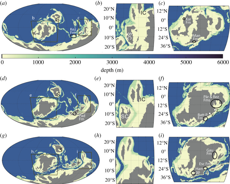
Figure 1.
The model bathymetry for 420 Ma (a), 400 Ma (d) and 380 Ma (g), with depth saturating at 6000 m (Abyssal ocean is at 4200 m, with trenches at 6000 m). The bathymetry data are computed from the tectonic reconstructions in [26]. The major continents are as follows: Laurussia is highlighted as panels (c), (f) and (i), Gondwana is the major continent in the south of panels, and Siberia is located NE of Laurussia denoted as S in panels (a), (d) and (g). The South China region is highlighted in panels (b), (e) and (h), with South China denoted as SC and Indochina as IC. The tidal proxies have been indicated in each time slices; Kez Fm, Keziertage Formation; Kar Fm, Karheen Formation; Man Fm, Manlius Formation; Pad Fm, Padeha Formation; Batt P Fm, Battery Point Formation; Pär and Rez Fms, Pärnu and Rēzekne Formations; Gau Fm, Gauja Formation; Ham gp, Hamilton Group and Esc Fm, Escuminac Formation. The stars in (f) indicate the locations of the two earliest fossil tetrapod trackways. Zachelmie is denoted by Z and Valentia Island as V (see §1 for details). (Online version in colour.)

