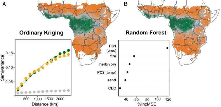
Fig. 4.
Spatial and environmental predictions of the biome index. We predicted the distribution of the biome index across the climatic space covered by the floristic surveys using (A) spatial information only vs. (B) a random forest approach based on environmental determinants. For the spatial predictions, we interpolated the distribution of the percentage of forest specialists, generalists, and savanna specialists using ordinary kriging and recomputed the biome index. The empirical semivariogram (points) and the spherical semivariogram model (lines) used for kriging and shown in A, Inset indicate that the spatial structure of generalist species is weaker and more homogeneous than that of forest and savanna specialists. For the environmental predictions of the biome index, we used climate (described by PC1 and PC2) (Fig. 1A), fire, herbivory (total biomass of both livestock and wild herbivores), and soil factors (described by the percentage of sand and cation exchange capacity, CEC, in the first 0 to 5 cm). The relative importance of each environmental determinant is shown in B, Inset. The importance (percentage increase in mean squared error, MSE) tests how the accuracy of the results is affected if the input variable is randomly permuted. White pixels in A correspond to areas outside the geographical extent and the environmental range covered by the floristic surveys. White pixels in B additionally contain pixels for which herbivory data were not available (coastal edge and edge of inland water bodies). Major water bodies are shown in blue.

