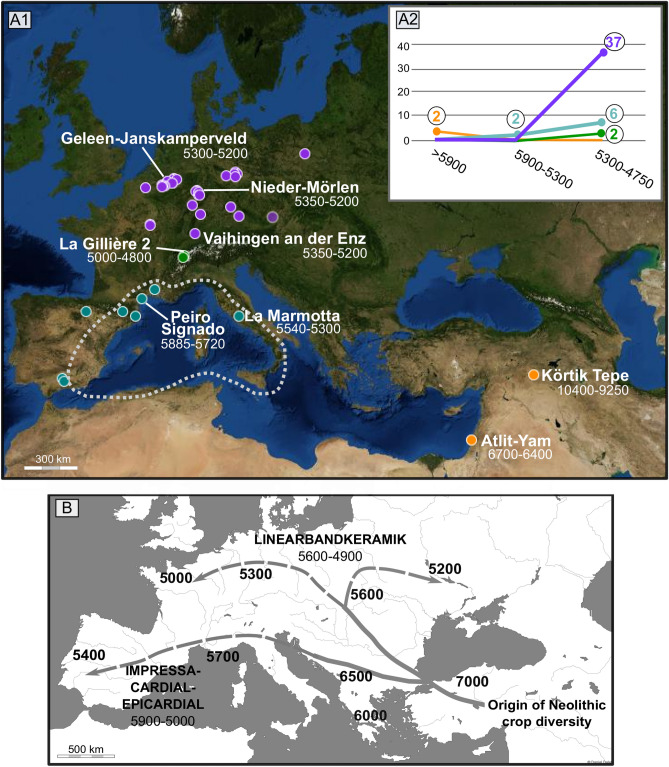
Figure 1.
(A1) Dataset of the Early Neolithic sites where opium poppy remains have been identified (Supplementary Information S1) with the locations of the earliest records in the Near East (orange circles), Mediterranean (blue circles), temperate Europe (purple circles), the western Alps (green circles), and current wild poppy populations (dotted line)11. The open access map was created with umap, an OpenStreetMap project (version 1.2.2), under ODbL 1.0 license. Contains credits: A. Salavert (AASPE, MNHN-CNRS), Map background credits: NASA 2016: https://umap.openstreetmap.fr/fr/map/salavertetal_sr_fig12_460185. (A2) Number of Early Neolithic sites where the plant is identified by chronological ranges corresponding to the period before the arrival of the first European farmers (< 5900 BCE); to the beginning of the Early Neolithic in the Mediterranean and temperate Europe (5900–5300 BCE); to the second stage of the LBK (LBK II–V) and the beginning of the Early Neolithic in the western Alps until the end of the period in western Europe (5300–4750 BCE).; (B) Overview of the spatial and temporal framework for the diffusion of the “Neolithic crop package” from the Near East to western Europe and the two European pioneer Neolithic complexes. The main chronological points are in cal BCE18. Contains credits: A. Salavert (AASPE, MNHN-CNRS), Map background credits: D. Dalet.

