
Fig. 1. South Sulawesi study area.
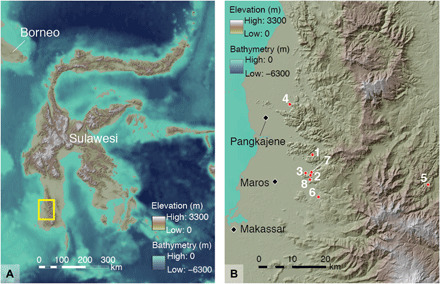
(A) The rock art sites under study are all situated in limestone karst areas in the island’s southwestern peninsula [see (B) for detail of area shown inside the rectangle]. (B) Locations of limestone caves or shelters discussed in the study: 1, Leang Tedongnge; 2, Leang Timpuseng; 3, Leang Barugayya 2; 4, Leang Bulu’ Sipong 4; 5, Gua Uhallie; 6, Leang Balangajia 1; 7, Leang Bulu Bettue; and 8, Leang Burung 2. Map data: Shuttle Radar Topography Mission 1 Arc-Second Global by NASA/NGS/USGS and GEBCO_2014 Grid version 20150318 (http://gebco.net). Base maps were created by M. Kottermair and A. Jalandoni.