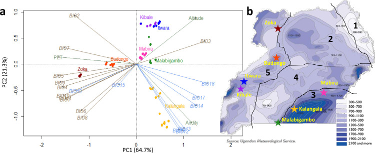
Fig 1. Environmental context of the sampled populations.
a- Principal component analysis (PCA) of 22 environmental variables at Ugandan C. canephora native sites. For the BIOx (see S3 Table), temperature-related variables are shown in grey-brown; precipitation-related in blue. Elevation, aridity index (AI) and potential evapotranspiration (PET) are shown in green. The first two axes, i.e. PC1 and PC2, account for 64.7% and 21.3% of the total variation, respectively. b- The seven natural forests are reported on the Ugandan map of average annual rainfall from the Ugandan Meteorological Service (NEMA, 2009) [34]. The five climatic zones based on precipitation [Matete et al. 2010] [33] are delimitated in grey. They include: 1. Karamoja, 2. Acholi-Kyoga, 3. Lake. Victoria, 4. Ankole-Southern Uganda and 5. Western Uganda areas. Climatic zones:3, 4 and 5 are important with regard to the presence of wild and cultivated of C. canephora populations. National Environment Management Authority (NEMA). 2009. Uganda: Atlas of our changing environment. NEMA, Kampala, Uganda.

