
Fig. 6. Suggested pathways and mixing area of the water underneath Thwaites ice tongue and Eastern Ice Shelf inferred from the data presented.
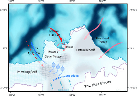
Red arrows indicate main pathways of warm salty water, blue arrow indicates outflow of meltwater-laden fresher water, and red dashed arrow indicates possible warm salty inflow below the range of the ship-borne ADCP. Blue shading shows bathymetric troughs, and purple lines indicate grounding zones. The two arrows from Pine Island Trough indicate that it is not possible from the present dataset to identify which part of this region sources the deep water.