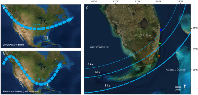
Figure 5.
Diagram of the two dominant patterns of winter atmospheric circulation over North America in relation to our study area: (a) dominance of zonal flow, which suppresses the transport of cold air to the southeastern United States and (b) dominance of meridional flow, which is associated with increased frequency of winter cold fronts reaching the southern United States including to southern Florida (bounding box)26. Southern Florida is expanded in (c), which shows the approximate trajectory (~ 45° angle) of winter cold fronts in this region91 in relation to our sampling locations on the Palm Beach Outer Reef (blue circle), the Broward Inner Reef (green triangle), and the Miami Inner Reef (orange triangle). This panel provides a hypothetical conceptual model (dashed lines) of when extreme winter cold fronts would reach different latitudes in southeast Florida with high enough frequency to suppress reef development. We suggest that extreme winter weather would have impacted increasingly southern latitudes over the Holocene in response to climate forcing. Cold front intensity may have also increased over time, a trend represented by the thickness of the dashed lines. Map image is the intellectual property of Esri and is used herein under license.
Copyright 2020 Esri and its licensors. All rights reserved.

