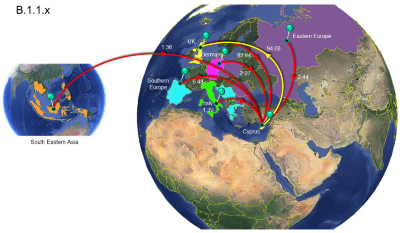
Figure 8.
Map of SARS-CoV-2 B.1.1.x clade group transmission between Cyprus and other countries. The geographic origins of SARS-CoV-2 B.basal imported into Cyprus based on the statistical phylogeographic analysis are shown as red lines, and exports from Cyprus to other countries are shown as yellow lines. Countries and groups of countries acting as “sources” or “sinks” for SARS-CoV-2 B.1.1.x transmission are highlighted and labeled, and the average number of migration events is indicated. The highlighted area of Eastern Europe consists of Bulgaria, Romania, the Czech Republic, Poland and Russia, and the highlighted area of southern Europe consists of Bosnia and Herzegovina, Croatia, Greece, Montenegro, Serbia, Portugal and Spain. The highlighted area of southeastern Asia consists of Cambodia, the Philippines, Taiwan, Thailand, Indonesia, Singapore and Malaysia. Map images courtesy of Google Earth Pro 7.3.2.5776 (14 December 2015). Center: Global view centered on Europe. 36°16′38.78″ N 36°07′29.71″ E, Eye alt 7949.12 km. US Dept. of State Geographer, DATA SIO, NOAA, U.S. Navy, NGA, GEBCO. Image Landsat/Copernicus. 2018 © Google. Left: Southeastern Asia Region: 6°16′52.33″ N 113°55′29.68″ E -18 m, Eye alt 8880.55 km, Image Landsat/Copernicus, US Dept. of State Geographer, Data SIO, NOAA, U.S. Navy, NGA, GEBCO, © 2021 Google. https://www.google.com/earth/versions/#earth-pro (accessed on 10 April 2019 and 23 March 2021).

