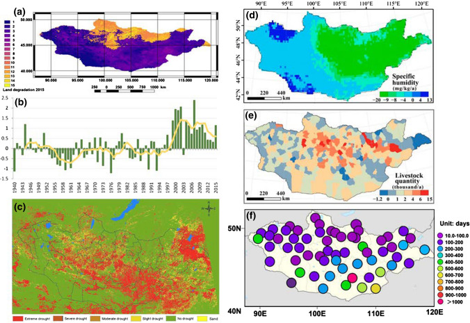
Fig. 5.
(a) Land degradation rate in Mongolia reprinted from Kim et al. (2020). According to the empirical models, 76.8% of the land is degraded, of which 22.9% is severely degraded. Assuming that land degradation from desertification is found in arid, semi-arid, dry, and sub-humid areas, the total desertified portion was 64.7%. The method and map of land degradation are developed by the Institute of Geography and Geoecology, Mongolian Academy of Sciences. (b) Interannual change of drought-summer condition index over Mongolia (averaged between May–August). Negative values indicate good summer condition, with positive values indicating drought.
Adopted from the Third National Communication by the Ministry of Environment and Tourism of Mongolia (METM, 2018). (c) A drought map of Mongolia in the ten-day period starting June 21, 2020. Drought conditions persisted over four months (June 1 to September 30, 2020) in Mongolia with varying degrees of severity across the country. Mongolia as a semi-arid and arid country belongs to a region with high risk of drought. In the five successive years between 2015–2020, drought was widely observed in Mongolia, mostly in summer from June to August. Historical drought maps can be accessed from the National Remote Sensing Center, Information and Research Institute of Meteorology, Hydrology and Environment of Mongolia (NRSC, 2021). Spatial distributions of specific humidity (d) and livestock quantity (e) from 1982 to 2015. Reprinted from Meng et al. (2020). Distribution of total dust events (unit: days) from 2000 to 2017 for severe and moderate sandstorms (f). Reprinted from Zhou et al. (2019)

