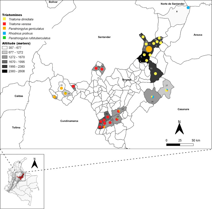
Fig 1. Distributions of triatomines collected in the 29 infested municipalities in Boyaca Department (Colombia) between 2017 and 2018.
Grayscale box represent the altitudinal ranges (m.a.s.l.). Yellow circle - T. dimidiata, red circle - T. venosa, orange circle - P. geniculatus, blue circle - R. prolixus and green circle - P. rufotuberculatus. Altitude ranges are illustrated in grayscale. 1-Boavita, 2-Covarachia, 3-San Mateo, 4-Sativa Norte, 5-Soata, 6-Susacon, 7-Tipacoque, 8-Cubara, 9-El Espino, 10-Guacamayas, 11-Panqueba, 12-Zetaquira, 13-Miraflores, 14-Garagoa, 15-Pachavita, 16-Chinavita, 17-Sutatenza, 18-Tenza, 19-Guateque, 20- La Capilla, 21-Socota, 22-Briceño, 23-La Victoria, 24-Maripi, 25-San Pablo de Borbur, 26-Labranza Grande, 27-Paya, 28-Chirataque, 29-San Jose de Pare. The size of circles corresponds to number of triatomines recollected. Big circles more than 100 and small circles less than 100. The map was built using the free and open source QGIS software version 3.4 (https://www.qgis.org/en/site/forusers/download.html) and shapefiles were obtained from the free and open source DIVA-GIS site (https://www.diva-gis.org/gdata).

